EMODnet Human Activities, Dredging
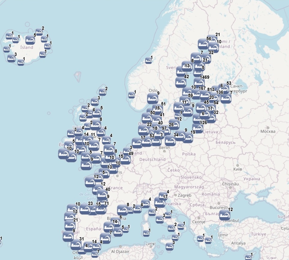
The dataset on dredging in the European seas was created in 2014 by AZTI for the European Marine Observation and Data Network (EMODnet) and it is the result of the aggregation and harmonization of data provided by several sources from all across the Europe. It is available for viewing and download on EMODnet web portal (Human Activities, https://emodnet.ec.europa.eu/en/human-activities). The dataset contains points representing dredging sites in the following countries: Belgium, Bulgaria, Cyprus, Denmark, Estonia, Finland, France, Germany, Greece, Iceland, Ireland, Italy, Latvia, Lithuania, Malta, Norway, Poland, Portugal, Spain, Sweden, The Netherlands and United Kingdom. Where available, each point has the following attributes: Id (Identifier), Position Information (e.g.: Estimated, Original, Polygon centroid of dredging area, Polygon centroid of dredging polygon), Country, Sea basin, Sea, Extraction Area, Year (when data is for a time period, the first year of the period is indicated), Permitted Amount (m3), Permitted Amount (t), Extracted Amount (m3), Extracted Amount (t), Extraction Type (e.g.: Harbour dredging, Estuary dredging, Sea lane), Purpose (e.g.: Maintenance dredging, Capital dredging, Others), End Use (e.g.: Beach nourishment, Commercialization, Confined deposit, Construction material, Embankment, Filling material, Land deposit, Reuse, Sea disposal, Wetland restoration), Material type (e.g.: silt, sand, gravel), Notes, Link to Web Sources. In the 2025 update, extraction data until 2024 has been included.
Simple
- Date (Publication)
- 2021-11-06
- Date (Revision)
- 2025-11-03
- Date (Creation)
- 2014-06-04
- Citation identifier
- EMODnet_HA_Dredging_20251103
- Point of contact
-
Organisation name Individual name Electronic mail address Role AZTI
Author Denmark-Ministry of Environment and Food of Denmark, Nature Agency
Resource provider Basin Directorate for Water Management in the Black Sea Region - Varna
Resource provider Cyprus-Cyprus Port Authority
Resource provider SEDNET
Resource provider Malta-Malta Environment and Planning Authority
Resource provider Italy-Francesco Baittiner
Resource provider Dredging, Environmental and Marine Engeneering
Resource provider Italy-Autorita Portuale di Piombino
Resource provider Italy-Autorita Portuale di Genova
Resource provider Spain-Basque Government, Direccion de Puertos y Asuntos Maritimos
Resource provider OSPAR (Dumping of Wastes or Other Matter at Sea)
Resource provider Spain-Puertos del Estado
Resource provider Spain-Ministerio para la Transición Ecológica y el Reto Demográfico (MITECO), Dirección General de la Costa y el Mar
Resource provider Portugal-APA-APFF, Dire��o de Gest�o de Espa�os, Ambiente e Infraestruturas
Resource provider France-CEREMA
Resource provider HELCOM (Dredging)
Resource provider UK-Port of London Authority (PLA)
Resource provider UK-Cowes Harbour Commission
Resource provider UK-Associated British Ports (ABP) Southampton
Resource provider Ireland-Department of Housing, Local Government and Heritage
Resource provider UK-Foyle and Marine Dredging
Resource provider UK-Marintime Journal
Resource provider Netherlands-Boskalis
Resource provider Netherlands-Van Oord
Resource provider Netherlands-Offshore Energ
Resource provider Denmark-Rohde-Nielsen
Resource provider Denmark-HOJ, Nordic Marine
info@hojmarine
Resource provider Estonia-Victoria Shippin
Resource provider Iceland-Ministry of Infrastructure, Department of Transport and Infrastructure
Resource provider Portugal-Laboratorio Nacional de Engenharia Civil
Resource provider Italy-Autorita di Sistema Portuale del Mar Tirreno Centrale
Resource provider Italy-Capitaneria di Porto di Livorno
Resource provider Italy-Livorno24-Quotidiano online
Resource provider Italy-RCM Costruzioni
Resource provider Italy-Autorita di Sistema Portuale dei Mari Tirreno Meridionale e Ionio
Resource provider Italy-Autorita si Sistema Portuale dei Mare Adriatico Centrale
Resource provider Italy-Regione Emilia-Romagna
Resource provider
-
GEMET - INSPIRE themes, version 1.0
-
-
Mineral resources
-
-
GEMET - Concepts, version 2.4
-
-
material
-
resource utilisation
-
waste
-
- Access constraints
- Other restrictions
- Other constraints
- No limitations on public access
- gmd:useconstraints
- otherRestrictions
- Other constraints
-
Creative Commons CC-BY 4.0 https://creativecommons.org/licenses/by/4.0/
- gmd:useconstraints
- otherRestrictions
- Other constraints
-
This data was downloaded from the EMODnet Portal ( https://emodnet.ec.europa.eu/en/). The data originator is AZTI.
- Spatial representation type
- Vector
- Language
- English
- Topic category
-
- Utilities communication
))
- Begin date
- 1964-01-01
- End date
- 2024-12-31
- Reference system identifier
- EPSG:4326
- Reference system identifier
- ISO 19108 calendar
- Transfer size
- 0
- OnLine resource
-
Protocol Linkage Name WWW:LINK
https://emodnet.ec.europa.eu/en/human-activities EMODnet Human Activities
OGC:WMS
https://ows.emodnet-humanactivities.eu/wms? dredging
OGC:WFS
https://ows.emodnet-humanactivities.eu/wfs? emodnet:dredging
WWW:DOWNLOAD
https://ows.emodnet-humanactivities.eu/geonetwork/srv/api/records/d3e86612-35a7-4c0f-a995-245062fd2792/attachments/EMODnet_HA_Dredging_20251103.zip EMODnet_HA_Dredging_20251103.zip
- Distribution format
-
Name Version Esri geodatabase Esri shapefile
- Hierarchy level
- Dataset
Conformance result
- Date (Publication)
- 2008-12-04
- Explanation
-
See the referenced specification
Conformance result
- Date (Publication)
- 2009-12-15
- Explanation
-
See the referenced specification
Conformance result
- Date (Publication)
- 2010-12-08
- Explanation
-
See the referenced specification
- Statement
-
Data were retrieved from different sources. Validation and quality assurance remain up to primary data sources, while harmonization is carried out by AZTI. The harmonisation process consisted of identifying a set of attributes common to all the different datasets, thus creating a single data model. To do so, it was necessary to define a homogenous set of variables for each attribute. Therefore, raw data attributes may use a different terminology, although the information contained remains basically the same. When the extraction site was not georrefered in the original dataset, coordinates were estimated based on the available information (e.g., the port name). For further information on validation and quality assurance, it is suggested that primary data sources are contacted. Generally speaking, data are to be considered very reliable, because they come from national sources officially in charge for their collection.
Metadata
- File identifier
- d3e86612-35a7-4c0f-a995-245062fd2792 XML
- Metadata language
- English
- Character set
- UTF8
- Hierarchy level
- Dataset
- Date stamp
- 2025-11-18T11:16:58.068939Z
- Metadata standard name
-
ISO19115
- Metadata standard version
-
2003/Cor.1:2006
- Metadata author
-
Organisation name Individual name Electronic mail address Role AZTI
Point of contact AZTI
Point of contact
Overviews
Spatial extent
Provided by
