EMODnet Human Activities, Military Areas
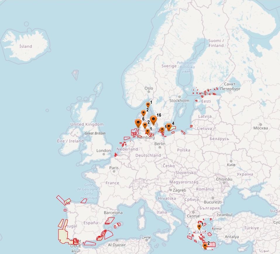
The dataset on offshore military areas in the European seas was created in 2020 by CETMAR for the European Marine Observation and Data Network (EMODnet). It is the result of the aggregation and harmonization of datasets provided by several sources. It is updated every year and is available for viewing and download on EMODnet web portal (Human Activities, https://emodnet.ec.europa.eu/en/human-activities). The dataset contains points and/or (where available) polygons representing offshore military areas in the following countries: Belgium, Bulgaria, Denmark, Estonia, Finland, France, Germany, Greece, Ireland, Latvia, Lithuania, Netherlands, Poland, Portugal, Spain and Sweden. Each point and/or polygon has the following attributes (where available): Country, Country_2, Country_3, Status (Active, Deactivated, Unknown, Planned), Type_1 (Firing Area, Air Force Exercise, Surface Exercise, Underwater Exercise, Mine Hunting Exercise, National Defence Area), Type_2, Type_3, Resource, Distance to coast (metres) and Area (square kilometres). The distance to coast (EEA coastline shapefile) has been calculated using the UTM WGS84 Zone projected coordinate system where data fall in.
Simple
- Date (Publication)
- 2021-02-03
- Date (Revision)
- 2025-03-14
- Date (Creation)
- 2021-02-01
- Citation identifier
- EMODnet_HA_MilitaryAreas_20250314
- Point of contact
-
Organisation name Individual name Electronic mail address Role Centro Tecnologico del Mar - Fundación CETMAR
Author Federal Public Service (FPS) Health, Food Chain Safety and Environment
Resource provider MRDPW - Ministry of Regional Development and Public Works (NCRD - National Centre for Regional Development)
Resource provider Danish Maritime Authority
Resource provider Ministry of Defence (Defence Investments Department)
Resource provider Ministry of The Environment and Regionals councils (Uusimaa, Kymenlaakso, Southwest Finland, Satakunta, Ostrobothnia, Central Ostrobothnia, North Ostrobothnia and Lapland)
Resource provider SHOM
Resource provider BSH - Federal Maritime and Hydrographic Agency
Resource provider HNHS - Hellenic Navy Hydrographic Service
Resource provider Marine Institute
Resource provider Ministry of Environmental Protection and Regional Development of The Republic of Latvia
Resource provider HELCOM - Baltic Marine Environment Protection Commission - Helsinki Commission
Resource provider Ministry of Defence (Hydrographic Service – Royal Navy)
Resource provider Maritime Office Gdynia
Resource provider DGRM - Direção-Geral de Recursos Naturais, Segurança e Serviços Marítimos
Resource provider IHM - Instituto Hidrográfico de la Marina
Resource provider Försvarsmakten
Resource provider Swedish Agency for Marine and Water Management
Resource provider
-
GEMET - INSPIRE themes, version 1.0
-
-
Utility and governmental services
-
-
GEMET - Concepts, version 4.1.4
-
-
military zone
-
military activities
-
defence
-
- Denominator
- 100000
- Language
- English
))
- Begin date
- 2021-02-01
- Access constraints
- Other restrictions
- Other constraints
- No limitations on public access
- gmd:useconstraints
- otherRestrictions
- Other constraints
-
Creative Commons CC-BY 4.0 https://creativecommons.org/licenses/by/4.0/
- gmd:useconstraints
- otherRestrictions
- Other constraints
-
This data was downloaded from the EMODnet Portal ( https://emodnet.ec.europa.eu/en/). The data originator is CETMAR.
- OnLine resource
-
Protocol Linkage Name WWW:LINK
https://emodnet.ec.europa.eu/en/human-activities EMODnet Human Activities
OGC:WMS
https://ows.emodnet-humanactivities.eu/wms? militaryareas
OGC:WMS
https://ows.emodnet-humanactivities.eu/wms? militaryareaspoly
OGC:WFS
https://ows.emodnet-humanactivities.eu/wfs? emodnet:militaryareas
OGC:WFS
https://ows.emodnet-humanactivities.eu/wfs? emodnet:militaryareaspoly
WWW:DOWNLOAD
https://ows.emodnet-humanactivities.eu/geonetwork/srv/api/records/579e4a3b-95e4-48c6-8352-914ebae0ae1d/attachments/EMODnet_HA_MilitaryAreas_20250314.zip EMODnet_HA_MilitaryAreas_20250314.zip
- Distribution format
-
Name Version Esri geodatabase gco:nilReason="unknown"> Esri shapefile gco:nilReason="unknown">
- Hierarchy level
- Dataset
Conformance result
- Date (Publication)
- 2008-12-04
- Explanation
-
See the referenced specification
Conformance result
- Date (Publication)
- 2009-12-15
- Explanation
-
See the referenced specification
Conformance result
- Date (Publication)
- 2010-12-08
- Explanation
-
See the referenced specification
- Statement
-
Data were retrieved from different countries, i.e. Belgium, Bulgaria, Denmark, Estonia, Finland, Germany, Greece, Ireland, Latvia, Lithuania, Netherlands, Poland, Portugal, Spain and Sweden. Validation and quality assurance remain up to primary data sources, while harmonization is carried out by CETMAR. For further information on validation and quality assurance, it is suggested that primary data sources are contacted. Generally speaking data are to be considered very reliable, because they come from national sources officially in charge for their collection.
Metadata
- File identifier
- 579e4a3b-95e4-48c6-8352-914ebae0ae1d XML
- Metadata language
- English
- Character set
- MD_CharacterSetCode_utf8
- Hierarchy level
- Dataset
- Date stamp
- 2025-09-02T08:01:55.997126Z
- Metadata standard name
-
ISO19115
- Metadata standard version
-
2003/Cor.1:2006
- Metadata author
-
Organisation name Individual name Electronic mail address Role Centro Tecnologico del Mar - Fundación CETMAR
Point of contact
Overviews
Spatial extent
Provided by
