EMODnet Human Activities, Fisheries, Fishing Intensity
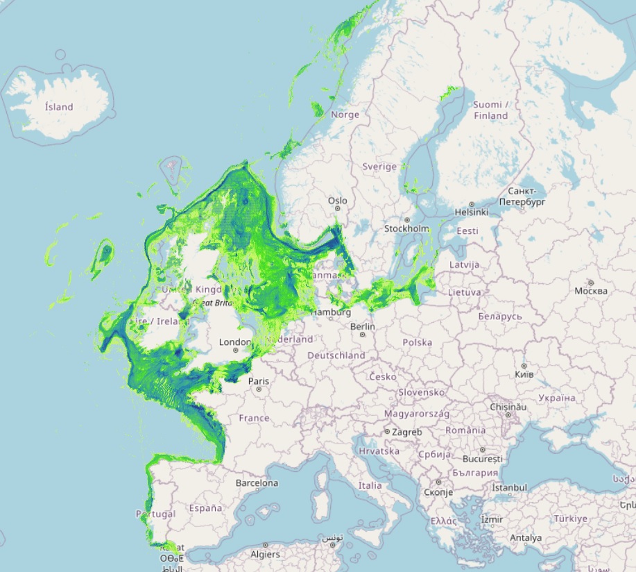
The datasets on fishing intensity in the EU waters by sea basin are created every year by the International Council for the Exploration of the Sea (ICES). In the 2020 Cogea started to collect and harmonize them according to the EMOdnet Human Activities dataset schema. The EMODnet dataset is updated yearly, as soon as new data from ICES Fishing Overviews are released, and is available for viewing and download on the EMODnet web portal (Human Activities, https://emodnet.ec.europa.eu/en/human-activities). Where and when available, the fisheries overview fishing intensity data concern: i) the spatial distribution of average annual fishing effort (mW fishing hours) by ecoregion (Azores, Bay of Biscay and the Iberian Coast, Baltic Sea, Barents Sea, Celtic Seas, Faroes, Greater North Sea, Icelandic Waters, Norwegian Sea and Oceanic Northeast Atlantic) and by gear type (Beam trawls, Bottom otter trawls, Bottom seines, Dredges, Pelagic trawls and seines, Static gears). Fishing effort data are only shown for vessels >12 m having vessel monitoring systems (VMS); ii) the average annual subsurface (top) and surface (bottom) mobile bottom contacting fishing gear (i.e. bottom otter trawls, bottom seines, dredges, beam trawls) disturbance by ecoregion in the Bay of Biscay and the Iberian Coast, Baltic Sea, Barents Sea, Celtic Seas, Faroes, Greater North Sea, Icelandic Waters, Norwegian Sea and Oceanic Northeast Atlantic, expressed as average swept-area ratios (SAR). Due to data confidentiality issues, VMS/logbook data are anonymized and aggregated in a 0.05×0.05 degree grid prior to submission to ICES, using the C-squares geocode system (polygons). The last data loaded into the database, from the ICES 2024 Fishing Overview update or revision (where available), report the 2019-2022 averages. Historical data area also included in the database, starting from the 2020 fishing overview, and reporting the 2015-2018, 2017-2020, 2018-2021, and 2019-2020 averages.
Simple
- Date (Publication)
- 2020-02-26
- Date (Revision)
- 2025-03-03
- Date (Creation)
- 2020-02-16
- Citation identifier
- EMODnet_HA_Fisheries_Fishing_Intensity_20250303
- Point of contact
-
Organisation name Individual name Electronic mail address Role Cogea srl
Author ICES
Resource provider
-
GEMET - INSPIRE themes, version 1.0
-
-
Agricultural and aquaculture facilities
-
-
GEMET - Concepts, version 2.4
-
-
Fisheries
-
- Use limitation
-
Re-use of content for commercial or non-commercial purposes is permitted free of charge, provided that the sources (EMODnet - Human Activities, STECF, and the FAO) are acknowledged. EMODnet - Human Activities accepts no responsibility or liability whatsoever for the re-use of content accessible on its website. For further information on ICES's data policy, please visit https://www.ices.dk/marine-data/guidelines-and-policy/Pages/default.aspx.
- Access constraints
- Other restrictions
- Other constraints
-
no limitation
- Spatial representation type
- Vector
- Language
- English
- Topic category
-
- Economy
))
- Begin date
- 2017-01-01
- End date
- 2022-12-31
- Reference system identifier
- EPSG:4326
- Reference system identifier
- ISO 19108 calendar
- Distribution format
-
Name Version Esri geodatabase
unknown
Esri shapefile
unknown
- Transfer size
- 0
- OnLine resource
- Hierarchy level
- Dataset
Conformance result
- Date (Publication)
- 2008-12-04
- Explanation
-
See the referenced specification
Conformance result
- Date (Publication)
- 2009-12-15
- Explanation
-
See the referenced specification
Conformance result
- Date (Publication)
- 2010-12-08
- Explanation
-
See the referenced specification
- Statement
-
Validation and quality assurance remain up to primary data sources, e.g. ICES, while the harmonization is carried out by Cogea. For further information on validation and quality assurance, it is suggested that primary data sources are contacted. Generally speaking data are to be considered very reliable, because they come from the source officially in charge for their collection.The yearly Ecoregions ICES's data (shapefiles) on fishing intensity are harmonized, imported into a single geodatabase, organised in two different tables (Effort: Average MW fishing hours by gear type, SAR: Average surface and subsurface swept area ratio) and a single C-Squares feature class (polygons). The tables are related to the feature class via relationship classes (C-square field). Date fields have also been added. All information is pre-validated by ICES.
Metadata
- File identifier
- d57fbdea-489e-4e11-9ff1-f0f706cfe783 XML
- Metadata language
- English
- Character set
- UTF8
- Hierarchy level
- Dataset
- Date stamp
- 2025-03-12T09:58:48.555852Z
- Metadata standard name
-
ISO19115
- Metadata standard version
-
2003/Cor.1:2006
- Metadata author
-
Organisation name Individual name Electronic mail address Role Cogea srl
Point of contact
Overviews
Spatial extent
Provided by
