• EMODnet Human Activities
  •   Search
  •   Map
  •   Sign in

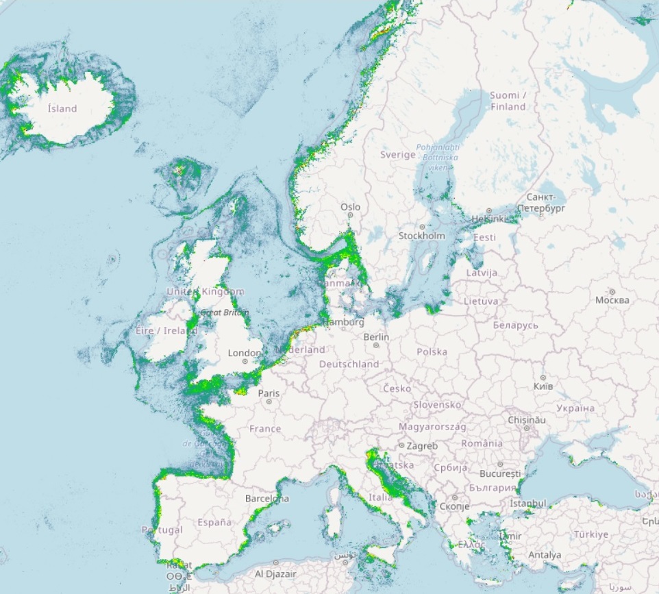
EMODnet Human Activities, Vessel Density Map

The Vessel Density maps in the EU are created since the 2019 by Cogea for the European Marine Observation and Data Network (EMODnet). The dataset is updated every year and is available for viewing and download on EMODnet web portal (Human Activities, https://emodnet.ec.europa.eu/en/human-activities). The maps are based on AIS data yearly purchased from Collecte Localisation Satellites (CLS) and ORBCOMM. The maps, GeoTIFF format, show shipping density in 1x1km cells of a grid covering all EU waters and some neighbouring areas. Density is expressed as hours per square kilometre per month. The following ship types are available:0 Other, 1 Fishing, 2 Service, 3 Dredging or underwater ops, 4 Sailing, 5 Pleasure Craft, 6 High speed craft, 7 Tug and towing, 8 Passenger, 9 Cargo, 10 Tanker, 11 Military and Law Enforcement, 12 Unknown and All ship types. Data are available by month of year. Yearly averages are also available.

Simple

Date (Publication)
2019-03-21
Date (Revision)
2024-03-04
Date (Creation)
2019-03-11
Citation identifier
EMODnet_HA_Vessel_Density_Map_20240304
Point of contact
Organisation name Individual name Electronic mail address Role

Cogea srl

lfalco@cogea.it

apititto@cogea.it

Originator

Cogea srl

lfalco@cogea.it

Author

Lovell Johns

william.adnams@lovelljohns.com

Author

CLS

pdebusschere@cls.fr

Resource provider

INSPIRE feature concept dictionary (Version: Linked Data 1.0)

  • Marine Layer

  • Marine Waterway

  • Transport Area

GEMET (version 3.1, 2012-07-20)

  • merchant shipping

  • maritime navigation

  • maritime transport

GEMET - INSPIRE themes, version 1.0

  • Transport networks

  • Geographical grid systems

Use limitation

Re-use of content for commercial or non-commercial purposes is permitted free of charge, provided that the sources (both EMODnet - Human Activities, and CLS) are acknowledged. EMODnet - Human Activities accepts no responsibility or liability whatsoever for the re-use of content accessible on its website.

Access constraints
Other restrictions
Other constraints

no limitation

Spatial representation type
Grid
Distance
1000  metre
Language
English
Topic category
  • Oceans
N
S
E
W
thumbnail


Begin date
2017-01-01
End date
2023-12-31
Reference system identifier
EPSG:3035
Reference system identifier
ISO 19108 calendar
Distribution format
Name Version

TIFF

6.0

Transfer size
0
OnLine resource
Protocol Linkage Name

WWW:LINK-1.0-http--link

https://emodnet.ec.europa.eu/en/human-activities

EMODnet Human Activities

WWW:DOWNLOAD-1.0-http--download

https://ows.emodnet-humanactivities.eu/geonetwork/srv/api/records/0f2f3ff1-30ef-49e1-96e7-8ca78d58a07c/attachments/EMODnet_HA_Vessel_Density_all_2017-2023.zip

EMODnet_HA_Vessel_Density_all_2017-2023.zip

WWW:DOWNLOAD-1.0-http--download

https://ows.emodnet-humanactivities.eu/geonetwork/srv/api/records/0f2f3ff1-30ef-49e1-96e7-8ca78d58a07c/attachments/EMODnet_HA_Vessel_Density_00_2017-2023.zip

EMODnet_HA_Vessel_Density_00_2017-2023.zip

WWW:DOWNLOAD-1.0-http--download

https://ows.emodnet-humanactivities.eu/geonetwork/srv/api/records/0f2f3ff1-30ef-49e1-96e7-8ca78d58a07c/attachments/EMODnet_HA_Vessel_Density_01_2017-2023.zip

EMODnet_HA_Vessel_Density_01_2017-2023.zip

WWW:DOWNLOAD-1.0-http--download

https://ows.emodnet-humanactivities.eu/geonetwork/srv/api/records/0f2f3ff1-30ef-49e1-96e7-8ca78d58a07c/attachments/EMODnet_HA_Vessel_Density_02_2017-2023.zip

EMODnet_HA_Vessel_Density_02_2017-2023.zip

WWW:DOWNLOAD-1.0-http--download

https://ows.emodnet-humanactivities.eu/geonetwork/srv/api/records/0f2f3ff1-30ef-49e1-96e7-8ca78d58a07c/attachments/EMODnet_HA_Vessel_Density_03_2017-2023.zip

EMODnet_HA_Vessel_Density_03_2017-2023.zip

WWW:DOWNLOAD-1.0-http--download

https://ows.emodnet-humanactivities.eu/geonetwork/srv/api/records/0f2f3ff1-30ef-49e1-96e7-8ca78d58a07c/attachments/EMODnet_HA_Vessel_Density_04_2017-2023.zip

EMODnet_HA_Vessel_Density_04_2017-2023.zip

WWW:DOWNLOAD-1.0-http--download

https://ows.emodnet-humanactivities.eu/geonetwork/srv/api/records/0f2f3ff1-30ef-49e1-96e7-8ca78d58a07c/attachments/EMODnet_HA_Vessel_Density_05_2017-2023.zip

EMODnet_HA_Vessel_Density_05_2017-2023.zip

WWW:DOWNLOAD-1.0-http--download

https://ows.emodnet-humanactivities.eu/geonetwork/srv/api/records/0f2f3ff1-30ef-49e1-96e7-8ca78d58a07c/attachments/EMODnet_HA_Vessel_Density_06_2017-2023.zip

EMODnet_HA_Vessel_Density_06_2017-2023.zip

WWW:DOWNLOAD-1.0-http--download

https://ows.emodnet-humanactivities.eu/geonetwork/srv/api/records/0f2f3ff1-30ef-49e1-96e7-8ca78d58a07c/attachments/EMODnet_HA_Vessel_Density_07_2017-2023.zip

EMODnet_HA_Vessel_Density_07_2017-2023.zip

WWW:DOWNLOAD-1.0-http--download

https://ows.emodnet-humanactivities.eu/geonetwork/srv/api/records/0f2f3ff1-30ef-49e1-96e7-8ca78d58a07c/attachments/EMODnet_HA_Vessel_Density_08_2017-2023.zip

EMODnet_HA_Vessel_Density_08_2017-2023.zip

WWW:DOWNLOAD-1.0-http--download

https://ows.emodnet-humanactivities.eu/geonetwork/srv/api/records/0f2f3ff1-30ef-49e1-96e7-8ca78d58a07c/attachments/EMODnet_HA_Vessel_Density_09_2017-2023.zip

EMODnet_HA_Vessel_Density_09_2017-2023.zip

WWW:DOWNLOAD-1.0-http--download

https://ows.emodnet-humanactivities.eu/geonetwork/srv/api/records/0f2f3ff1-30ef-49e1-96e7-8ca78d58a07c/attachments/EMODnet_HA_Vessel_Density_10_2017-2023.zip

EMODnet_HA_Vessel_Density_10_2017-2023.zip

WWW:DOWNLOAD-1.0-http--download

https://ows.emodnet-humanactivities.eu/geonetwork/srv/api/records/0f2f3ff1-30ef-49e1-96e7-8ca78d58a07c/attachments/EMODnet_HA_Vessel_Density_11_2017-2023.zip

EMODnet_HA_Vessel_Density_11_2017-2023.zip

WWW:DOWNLOAD-1.0-http--download

https://ows.emodnet-humanactivities.eu/geonetwork/srv/api/records/0f2f3ff1-30ef-49e1-96e7-8ca78d58a07c/attachments/EMODnet_HA_Vessel_Density_12_2017-2023.zip

EMODnet_HA_Vessel_Density_12_2017-2023.zip

WWW:DOWNLOAD-1.0-http--download

https://ows.emodnet-humanactivities.eu/geonetwork/srv/api/records/0f2f3ff1-30ef-49e1-96e7-8ca78d58a07c/attachments/EMODnet_HA_Vessel_Density_all_2017-2023Avg.zip

EMODnet_HA_Vessel_Density_all_2017-2023Avg.zip

WWW:DOWNLOAD-1.0-http--download

https://ows.emodnet-humanactivities.eu/geonetwork/srv/api/records/0f2f3ff1-30ef-49e1-96e7-8ca78d58a07c/attachments/EMODnet_HA_Vessel_Density_00_2017-2023Avg.zip

EMODnet_HA_Vessel_Density_00_2017-2023Avg.zip

WWW:DOWNLOAD-1.0-http--download

https://ows.emodnet-humanactivities.eu/geonetwork/srv/api/records/0f2f3ff1-30ef-49e1-96e7-8ca78d58a07c/attachments/EMODnet_HA_Vessel_Density_01_2017-2023Avg.zip

EMODnet_HA_Vessel_Density_01_2017-2023Avg.zip

WWW:DOWNLOAD-1.0-http--download

https://ows.emodnet-humanactivities.eu/geonetwork/srv/api/records/0f2f3ff1-30ef-49e1-96e7-8ca78d58a07c/attachments/EMODnet_HA_Vessel_Density_02_2017-2023Avg.zip

EMODnet_HA_Vessel_Density_02_2017-2023Avg.zip

WWW:DOWNLOAD-1.0-http--download

https://ows.emodnet-humanactivities.eu/geonetwork/srv/api/records/0f2f3ff1-30ef-49e1-96e7-8ca78d58a07c/attachments/EMODnet_HA_Vessel_Density_03_2017-2023Avg.zip

EMODnet_HA_Vessel_Density_03_2017-2023Avg.zip

WWW:DOWNLOAD-1.0-http--download

https://ows.emodnet-humanactivities.eu/geonetwork/srv/api/records/0f2f3ff1-30ef-49e1-96e7-8ca78d58a07c/attachments/EMODnet_HA_Vessel_Density_04_2017-2023Avg.zip

EMODnet_HA_Vessel_Density_04_2017-2023Avg.zip

WWW:DOWNLOAD-1.0-http--download

https://ows.emodnet-humanactivities.eu/geonetwork/srv/api/records/0f2f3ff1-30ef-49e1-96e7-8ca78d58a07c/attachments/EMODnet_HA_Vessel_Density_05_2017-2023Avg.zip

EMODnet_HA_Vessel_Density_05_2017-2023Avg.zip

WWW:DOWNLOAD-1.0-http--download

https://ows.emodnet-humanactivities.eu/geonetwork/srv/api/records/0f2f3ff1-30ef-49e1-96e7-8ca78d58a07c/attachments/EMODnet_HA_Vessel_Density_06_2017-2023Avg.zip

EMODnet_HA_Vessel_Density_06_2017-2023Avg.zip

WWW:DOWNLOAD-1.0-http--download

https://ows.emodnet-humanactivities.eu/geonetwork/srv/api/records/0f2f3ff1-30ef-49e1-96e7-8ca78d58a07c/attachments/EMODnet_HA_Vessel_Density_07_2017-2023Avg.zip

EMODnet_HA_Vessel_Density_07_2017-2023Avg.zip

WWW:DOWNLOAD-1.0-http--download

https://ows.emodnet-humanactivities.eu/geonetwork/srv/api/records/0f2f3ff1-30ef-49e1-96e7-8ca78d58a07c/attachments/EMODnet_HA_Vessel_Density_08_2017-2023Avg.zip

EMODnet_HA_Vessel_Density_08_2017-2023Avg.zip

WWW:DOWNLOAD-1.0-http--download

https://ows.emodnet-humanactivities.eu/geonetwork/srv/api/records/0f2f3ff1-30ef-49e1-96e7-8ca78d58a07c/attachments/EMODnet_HA_Vessel_Density_09_2017-2023Avg.zip

EMODnet_HA_Vessel_Density_09_2017-2023Avg.zip

WWW:DOWNLOAD-1.0-http--download

https://ows.emodnet-humanactivities.eu/geonetwork/srv/api/records/0f2f3ff1-30ef-49e1-96e7-8ca78d58a07c/attachments/EMODnet_HA_Vessel_Density_10_2017-2023Avg.zip

EMODnet_HA_Vessel_Density_10_2017-2023Avg.zip

WWW:DOWNLOAD-1.0-http--download

https://ows.emodnet-humanactivities.eu/geonetwork/srv/api/records/0f2f3ff1-30ef-49e1-96e7-8ca78d58a07c/attachments/EMODnet_HA_Vessel_Density_11_2017-2023Avg.zip

EMODnet_HA_Vessel_Density_11_2017-2023Avg.zip

WWW:DOWNLOAD-1.0-http--download

https://ows.emodnet-humanactivities.eu/geonetwork/srv/api/records/0f2f3ff1-30ef-49e1-96e7-8ca78d58a07c/attachments/EMODnet_HA_Vessel_Density_12_2017-2023Avg.zip

EMODnet_HA_Vessel_Density_12_2017-2023Avg.zip

WWW:DOWNLOAD-1.0-http--download

https://ows.emodnet-humanactivities.eu/geonetwork/srv/api/records/0f2f3ff1-30ef-49e1-96e7-8ca78d58a07c/attachments/EMODnet_HA_Vessel_Density_Grid_20190311.7z

EMODnet_HA_Vessel_Density_Grid_20190311.7z

OGC:WMS-1.3.0-http-get-map

https://ows.emodnet-humanactivities.eu/wms?

vesseldensity_all

OGC:WMS-1.3.0-http-get-map

https://ows.emodnet-humanactivities.eu/wms?

vesseldensity_00avg

OGC:WMS-1.3.0-http-get-map

https://ows.emodnet-humanactivities.eu/wms?

vesseldensity_00

OGC:WMS-1.3.0-http-get-map

https://ows.emodnet-humanactivities.eu/wms?

vesseldensity_01

OGC:WMS-1.3.0-http-get-map

https://ows.emodnet-humanactivities.eu/wms?

vesseldensity_02

OGC:WMS-1.3.0-http-get-map

https://ows.emodnet-humanactivities.eu/wms?

vesseldensity_03

OGC:WMS-1.3.0-http-get-map

https://ows.emodnet-humanactivities.eu/wms?

vesseldensity_04

OGC:WMS-1.3.0-http-get-map

https://ows.emodnet-humanactivities.eu/wms?

vesseldensity_05

OGC:WMS-1.3.0-http-get-map

https://ows.emodnet-humanactivities.eu/wms?

vesseldensity_06

OGC:WMS-1.3.0-http-get-map

https://ows.emodnet-humanactivities.eu/wms?

vesseldensity_07

OGC:WMS-1.3.0-http-get-map

https://ows.emodnet-humanactivities.eu/wms?

vesseldensity_08

OGC:WMS-1.3.0-http-get-map

https://ows.emodnet-humanactivities.eu/wms?

vesseldensity_09

OGC:WMS-1.3.0-http-get-map

https://ows.emodnet-humanactivities.eu/wms?

vesseldensity_10

OGC:WMS-1.3.0-http-get-map

https://ows.emodnet-humanactivities.eu/wms?

vesseldensity_11

OGC:WMS-1.3.0-http-get-map

https://ows.emodnet-humanactivities.eu/wms?

vesseldensity_12

OGC:WMS-1.3.0-http-get-map

https://ows.emodnet-humanactivities.eu/wms?

vesseldensity_allavg

OGC:WMS-1.3.0-http-get-map

https://ows.emodnet-humanactivities.eu/wms?

vesseldensity_01avg

OGC:WMS-1.3.0-http-get-map

https://ows.emodnet-humanactivities.eu/wms?

vesseldensity_02avg

OGC:WMS-1.3.0-http-get-map

https://ows.emodnet-humanactivities.eu/wms?

vesseldensity_03avg

OGC:WMS-1.3.0-http-get-map

https://ows.emodnet-humanactivities.eu/wms?

vesseldensity_04avg

OGC:WMS-1.3.0-http-get-map

https://ows.emodnet-humanactivities.eu/wms?

vesseldensity_05avg

OGC:WMS-1.3.0-http-get-map

https://ows.emodnet-humanactivities.eu/wms?

vesseldensity_06avg

OGC:WMS-1.3.0-http-get-map

https://ows.emodnet-humanactivities.eu/wms?

vesseldensity_07avg

OGC:WMS-1.3.0-http-get-map

https://ows.emodnet-humanactivities.eu/wms?

vesseldensity_08avg

OGC:WMS-1.3.0-http-get-map

https://ows.emodnet-humanactivities.eu/wms?

vesseldensity_09avg

OGC:WMS-1.3.0-http-get-map

https://ows.emodnet-humanactivities.eu/wms?

vesseldensity_10avg

OGC:WMS-1.3.0-http-get-map

https://ows.emodnet-humanactivities.eu/wms?

vesseldensity_11avg

OGC:WMS-1.3.0-http-get-map

https://ows.emodnet-humanactivities.eu/wms?

vesseldensity_12avg

OGC:WCS

https://ows.emodnet-humanactivities.eu/wcs?

emodnet:vesseldensity_all

OGC:WCS

https://ows.emodnet-humanactivities.eu/wcs?

emodnet:vesseldensity_00

OGC:WCS

https://ows.emodnet-humanactivities.eu/wcs?

emodnet:vesseldensity_01

OGC:WCS

https://ows.emodnet-humanactivities.eu/wcs?

emodnet:vesseldensity_02

OGC:WCS

https://ows.emodnet-humanactivities.eu/wcs?

emodnet:vesseldensity_03

OGC:WCS

https://ows.emodnet-humanactivities.eu/wcs?

emodnet:vesseldensity_04

OGC:WCS

https://ows.emodnet-humanactivities.eu/wcs?

emodnet:vesseldensity_05

OGC:WCS

https://ows.emodnet-humanactivities.eu/wcs?

emodnet:vesseldensity_06

OGC:WCS

https://ows.emodnet-humanactivities.eu/wcs?

emodnet:vesseldensity_07

OGC:WCS

https://ows.emodnet-humanactivities.eu/wcs?

emodnet:vesseldensity_08

OGC:WCS

https://ows.emodnet-humanactivities.eu/wcs?

emodnet:vesseldensity_09

OGC:WCS

https://ows.emodnet-humanactivities.eu/wcs?

emodnet:vesseldensity_10

OGC:WCS

https://ows.emodnet-humanactivities.eu/wcs?

emodnet:vesseldensity_11

OGC:WCS

https://ows.emodnet-humanactivities.eu/wcs?

emodnet:vesseldensity_12

OGC:WCS

https://ows.emodnet-humanactivities.eu/wcs?

emodnet:vesseldensity_allavg

OGC:WCS

https://ows.emodnet-humanactivities.eu/wcs?

emodnet:vesseldensity_00avg

OGC:WCS

https://ows.emodnet-humanactivities.eu/wcs?

emodnet:vesseldensity_01avg

OGC:WCS

https://ows.emodnet-humanactivities.eu/wcs?

emodnet:vesseldensity_02avg

OGC:WCS

https://ows.emodnet-humanactivities.eu/wcs?

emodnet:vesseldensity_03avg

OGC:WCS

https://ows.emodnet-humanactivities.eu/wcs?

emodnet:vesseldensity_04avg

OGC:WCS

https://ows.emodnet-humanactivities.eu/wcs?

emodnet:vesseldensity_05avg

OGC:WCS

https://ows.emodnet-humanactivities.eu/wcs?

emodnet:vesseldensity_06avg

OGC:WCS

https://ows.emodnet-humanactivities.eu/wcs?

emodnet:vesseldensity_07avg

OGC:WCS

https://ows.emodnet-humanactivities.eu/wcs?

emodnet:vesseldensity_08avg

OGC:WCS

https://ows.emodnet-humanactivities.eu/wcs?

emodnet:vesseldensity_09avg

OGC:WCS

https://ows.emodnet-humanactivities.eu/wcs?

emodnet:vesseldensity_10avg

OGC:WCS

https://ows.emodnet-humanactivities.eu/wcs?

emodnet:vesseldensity_11avg

OGC:WCS

https://ows.emodnet-humanactivities.eu/wcs?

emodnet:vesseldensity_12avg

Hierarchy level
Dataset

Conformance result

Date (Publication)
2008-12-04
Explanation

See the referenced specification

Pass
Yes

Conformance result

Date (Publication)
2009-12-15
Explanation

See the referenced specification

Conformance result

Date (Publication)
2010-12-08
Explanation

See the referenced specification

Pass
Yes
Statement

AIS data are annualy purchased from two commercial providers, CLS and ORBCOMM. The data consists of messages sent by automatic tracking systems installed on board ships and received by terrestrial and satellite receivers alike. The acquired datasets currently cover a period from 2017 to 2023 for an area covering all EU waters. A partial pre-processing of the data is carried out by CLS: (i) The only AIS messages delivered are the ones relevant for assessing shipping activities (AIS messages 1, 2, 3, 18 and 19). (ii) The AIS data are down-sampled to 3 minutes (iii). Duplicate signals are removed. (iv) Wrong MMSI signals are removed. (v) Special characters and diacritics are removed. (vi) Signals with erroneous speed over ground (SOG) are removed (negative values or more than 80 knots). (vii) Signals with erroneous course over ground (COG) are removed (negative values or more than 360 degrees). (viii) A Kalman filter is applied to remove satellite noise. The Kalman filter is based on a correlated random walk fine-tuned for ship behaviour. The consistency of a new observation with the modelised position is checked compared to key performance indicators such as innovation, likelihood and speed. (ix) A footprint filter is applied to check for satellite AIS data consistency. All positions which are not compliant with the ship-satellite co-visibility are flagged as invalid. The AIS data are converted from their original format (NMEA) to CSV, and deliverd to Cogea split into 12 files, each corresponding to a month of the year. By running a series of commands from Linux shell, all remaining invalid characters are removed as well as unnecessary fields. The data are then imported into a PostgreSQL relational database (with the PostGIS extension), each month in a different table containing the following specialised data types: mmsi (numeric), locdate (date), loctime (time without time zone), lon (double precision), lat (double precision), aisshiptype (character varying). MMSI numbers are often associated to more than a ship type during a year. To cope with this issue, a unique MMSI/ship type register is created every year. In the register, MMSI with multiple ship types are associated the most recurring and known ship type by counting the number of record for each combination mmsi/ship type. The admissible ship types reported in the AIS messages are grouped into macrocategories: 0 Other, 1 Fishing, 2 Service, 3 Dredging or underwater ops, 4 Sailing, 5 Pleasure Craft, 6 High speed craft, 7 Tug and towing, 8 Passenger, 9 Cargo, 10 Tanker, 11 Military and Law Enforcement, 12 Unknown and All ship types. The subsequent steps consist of creating points representing ship positions from the AIS messages, then reconstructing ship routes (lines) from the points for every two consecutive positions of a ship, by using the MMSI number as a unique identifier of a ship. In addition, for each line the query calculates its length (in km) and its duration (in hours) and append them both as attributes to the line. If the distance between two consecutive positions of a ship is longer than 30 km or if the time interval is longer than 6 hours, no line is created. Both datasets (points and lines) are projected into the ETRS89/ETRS-LAEA coordinate reference system, used for statistical mapping at all scales, where true area representation is required (EPSG: 3035). Points and lines calculations are based on custom-made sql scripts developed by Cogea. The lines obtained are then intersected with a custom-made 1x1km grid polygon (21 million cells) created by Cogea, based on the EEA's national grids, extended to cover the whole area of interest (all EU sea basins) and imported in PostGIS. Because each line has length and duration as attributes, it is possible to calculate how much time each ship spent in a given cell over a month by intersecting line records with grid cell records. This is done through a custom-made sql script developed by Lovell Johns. Using the PostGIS Intersect tool, for each cell of the grid, the time value of each 'segment' in it is summed, thus obtaining the density value associated to that cell, stored in calculated PostGIS tables. Density is thus expressed in hours per square kilometre per month. The final step consists of creating and compressing, in QGIS and GDAL and from the PostGIS vessel density tables, the final raster datasets (GeoTIFF format). Annual average rasters by ship type are also finally calculated. For more details on vessel density calculations method and concepts see the technical report 'EU Vessel Density Map - Detailed Method' published at: https://emodnet.ec.europa.eu/en/reports?field_emodnet_lot_value[]=human_activities. Comparared with the original method, starting from the 2021 (2020 data) the calculations of ship positions (points) and ship routes (lines) were sped up by moving them from ArcGIS to PostGIS through custom-made sql scripts developed by Cogea.

Metadata

File identifier
0f2f3ff1-30ef-49e1-96e7-8ca78d58a07c XML
Metadata language
English
Character set
UTF8
Hierarchy level
Dataset
Date stamp
2024-11-06T10:27:55.884339Z
Metadata standard name

ISO19115

Metadata standard version

2003/Cor.1:2006

Metadata author
Organisation name Individual name Electronic mail address Role

Cogea srl

lfalco@cogea.it

apititto@cogea.it

Point of contact


Overviews

overview

Spatial extent

N
S
E
W
thumbnail


Keywords


Provided by

logo
Access to the portal
Read here the full details and access to the data.

Associated resources

Not available


  •   About
  •   Github
  •