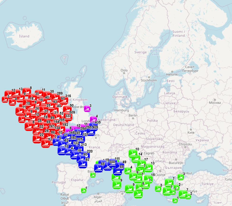
EMODnet Human Activities, Cultural Heritage, Ship wrecks
The dataset combines data collected from several sources: data collected and processed by the “Service hydrographique et océanographique de la marine” (SHOM) under the product “Wrecks and obstructions” for France (Hexagone and outermost regions and territories), The National Monument Service Wreck Viewer for Ireland, Historic England and the University of Oxford - The Oxford Roman Economy Project (Strauss, J. (2013). Shipwrecks Database. Version 1.0. Accessed (date): oxrep.classics.ox.ac.uk/databases/shipwrecks_database/) for archeological remains of ship wrecks in the Mediterranean. The different products were developed with different purposes and therefore provide information of different nature. The product developed by SHOM aims to identify objects emerging from the seabed and likely to hinder navigation, while the three other products focus on the historical value of the wrecks. The choice was made to keep as much information as possible. When possible fields from different sources have been merged (e.g. least depth available in SHOM data and the Oxford Roman Economy Project), but other fields correspond to a specific source. When available, information is provided on the nature of the objects (object description, ship characteristics, object type, artefacts, estimated tonnage), on the aging of the wrecks (sink year, dating, period), on the circumstances of the sinking (sink context, place of origine, place of destination), on the location (least depth, max depth, other depth information, object length, location precision, site area, coast distance), on the protection status (only for England) and on sources and additional information available (source information, references, website, website 2). Data from the National Monument Service Wreck Viewer in Ireland includes data from a variety of sources, including the UK Hydrographic Organisation. As there is a separate dataset based on the UKHO data, the corresponding records have been removed here. The additional processing carried out by EMODnet consisted in translating the available information to English (through partly-automated translation), extracting the year of the sinking when available and calculating the distance to coast. Last update of the product by SHOM was made in November 2022, last update of the Historic England data was made in March 2025, update of the National Monument Service Wreck Viewer in Ireland was made in August 2023, and the Oxford Roman Economy Project was carried out in 2013.
Simple
- Date (Creation)
- 2022-07-20
- Citation identifier
- EMODnet_HA_Heritage_Shipwrecks_20250409
- Point of contact
-
Organisation name Individual name Electronic mail address Role AND-International
Author Service hydrographique et océanographique de la marine (SHOM)- France
Resource provider National Monuments Service Wreck Viewer - Ireland
Resource provider Historic England
Resource provider University of Oxford - The Oxford Roman Economy Project
Resource provider
-
GEMET - INSPIRE themes, version 1.0
-
-
Protected sites
-
-
INSPIRE - Feature Concept Dictionary, version 3
-
-
Protected Site
-
-
GEMET - Concepts, version 4.2.1
-
-
culture (society)
-
-
GEMET - Concepts, version 4.2.1
-
-
wreck
-
-
GEMET - Themes, version 4.2.1
-
-
waste
-
-
GEMET - Groups, version 4.2.1
-
-
WASTES, POLLUTANTS, POLLUTION
-
- Use limitation
-
This product is derived from data products disseminated under the licence CC-BY-SA 4.0. Re-use of content for commercial or non-commercial purposes is permitted free of charge, provided that the sources (both EMODnet - Human Activities, SHOM, the NAtional Monuments Service Wrecks Viewer, Historic England and the Oxford Roman Economy Project) are acknowledged. Data from the Oxford Roman Economy Project should be referenced as: Strauss, J. (2013). Shipwrecks Database. Version 1.0. Accessed (date): oxrep.classics.ox.ac.uk/databases/shipwrecks_database/. Data from Historic England should be referenced as : © Historic England 2021. Contains Ordnance Survey data © Crown copyright and database right 2021. The Historic England GIS Data contained in this material was obtained on 20/08/2021. The most publicly available up to date Historic England GIS Data can be obtained from HistoricEngland.org.uk. EMODnet - Human Activities accepts no responsibility or liability whatsoever for the re-use of content accessible on its website.
- Access constraints
- Other restrictions
- Spatial representation type
- Vector
- Denominator
- 100000
- Language
- English
- Topic category
-
- Oceans
))
- Distribution format
-
Name Version Esri geodatabase
unknown
Esri shapefile
unknown
- Transfer size
- 0
- OnLine resource
-
Protocol Linkage Name WWW:LINK-1.0-http--link
https://emodnet.ec.europa.eu/en/human-activities EMODnet Human Activities
OGC:WMS-1.3.0-http-get-map
https://ows.emodnet-humanactivities.eu/wms? heritageshipwrecks
OGC:WFS
https://ows.emodnet-humanactivities.eu/wfs? emodnet:heritageshipwrecks
WWW:DOWNLOAD-1.0-http--download
https://ows.emodnet-humanactivities.eu/geonetwork/srv/api/records/e965088b-a265-4517-84df-c49b156af8a7/attachments/EMODnet_HA_Heritage_Shipwrecks_20250409.zip EMODnet_HA_Heritage_Shipwrecks_20250409.zip
- Hierarchy level
- Dataset
Conformance result
- Date
- 2020-12-23
- Explanation
-
See the referenced specification
- Statement
-
Depending on the source of information, the amount of information available on a specific wreck varies. More specific information on the metadata and quality of data can be found on the sources website.
Metadata
- File identifier
- e965088b-a265-4517-84df-c49b156af8a7 XML
- Metadata language
- English
- Character set
- MD_CharacterSetCode_utf8
- Hierarchy level
- Dataset
- Date stamp
- 2025-05-08T09:12:14.453319Z
- Metadata standard name
-
ISO19115
- Metadata standard version
-
2003/Cor.1:2006
- Metadata author
-
Organisation name Individual name Electronic mail address Role AND-International
Point of contact
Overviews

Spatial extent
))
Provided by
