EMODnet Human Activities, Oil and Gas, Offshore Installations
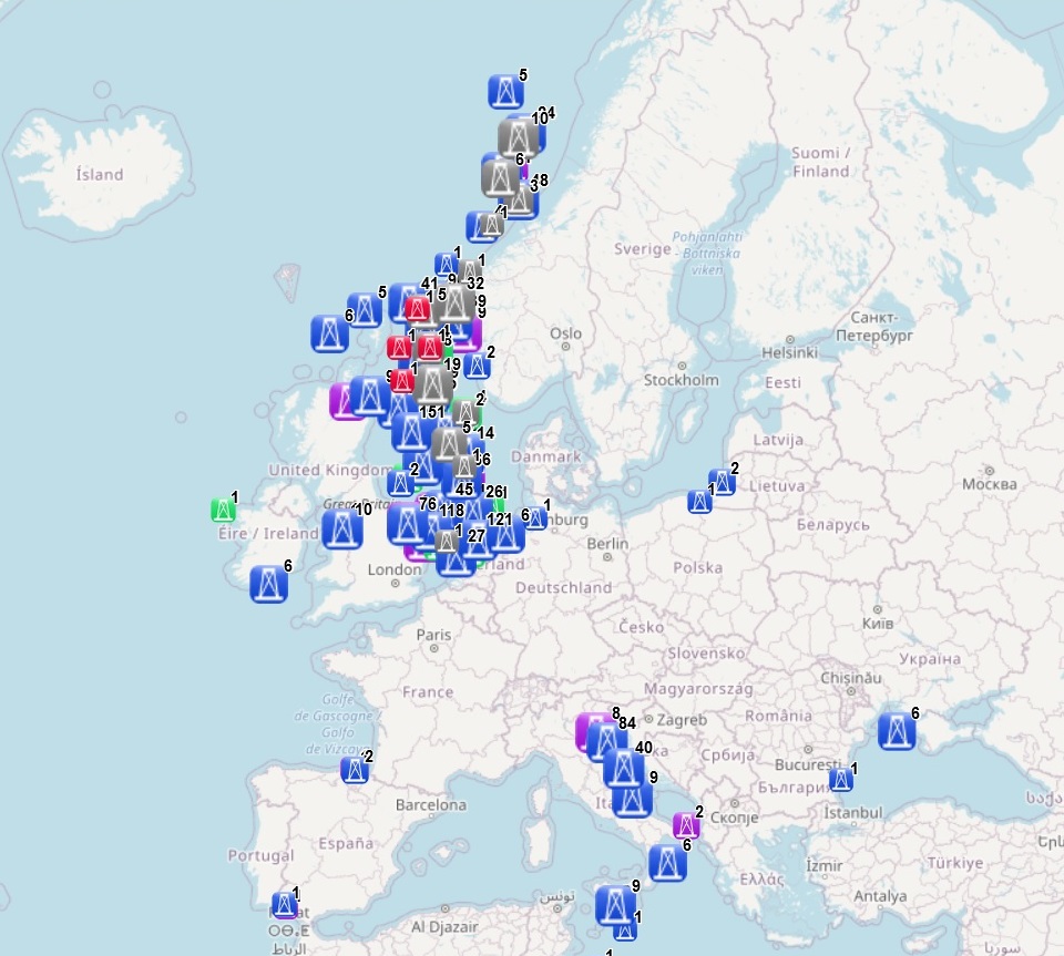
The dataset on offshore installations for Oil and Gas exploitation and exploration activities in the European seas was created in 2015 by Cogea for the European Marine Observation and Data Network (EMODnet). It is the result of the aggregation and harmonization of datasets provided by several EU and non-EU sources. It is updated every year and it is available for viewing and download on EMODnet web portal (Human Activities, https://emodnet.ec.europa.eu/en/human-activities). The dataset contains points representing offshore installations and where available each point has the following attributes: ID, name, country, location block, operator, production start year, primary production, current status, category and function of the installation, sub-structure and topside weights (tonnes), water depth (metres), distance to coast (metres) and notes. The OSPAR commission source covers data for Germany, Ireland, Spain (Atlantic Sea), while for Italy data have been collected and harmonized from the Italian Ministry of Economic Development, for Denmark from the Danish Energy Agency, for the Netherlands from the TNO - Geological Survey of the Netherlands, for Croatia from the Croatian Hydrocarbon Agency, for Norway from the Norwegian Petroleum Directorate, for the UK from the Oil and Gas Authority (surface infrastructures), for Polish and Russian installations in the Baltic Sea from Marine Traffic and Helcom, finally from Marine Traffic come the data for Bulgarian, Russian and Ukrainian installations in the Black Sea and for Spanish installations in the Mediterranean Sea.
Simple
- Date (Publication)
- 2015-08-14
- Date (Revision)
- 2024-02-16
- Date (Creation)
- 2015-08-06
- Citation identifier
- EMODnet_HA_OG_OffshoreInstallations_20240216
- Point of contact
-
Organisation name Individual name Electronic mail address Role Cogea Srl
Author Norway - Norwegian Petroleum Directorate
Resource provider Denmark - Danish Energy Agency
Resource provider Croatia - Croatian Hydrocarbon Agency
Resource provider Marine Traffic
Resource provider Helsinki Commission
Point of contact OSPAR Commission
Resource provider Italy - Ministero dello Sviluppo Economico - Direzione Generale per le risorse Minerarie ed Energetiche
Resource provider Netherlands - TNO - Geological Survey of the Netherlands
Resource provider UK - North Sea Transition Authority
Resource provider
-
GEMET - INSPIRE themes, version 1.0
-
-
Energy resources
-
-
GEMET - Themes, version 2.4
-
-
energy
-
-
GEMET - Concepts, version 3.1
-
-
hydrocarbon
-
oil exploration
-
oil extraction
-
offshore drilling
-
oil production (chain)
-
petroleum industry
-
- Denominator
- 100000
- Language
- English
- Topic category
-
- Utilities communication
))
- Access constraints
- Other restrictions
- Other constraints
- No limitations on public access
- gmd:useconstraints
- otherRestrictions
- Other constraints
-
Creative Commons CC-BY 4.0 https://creativecommons.org/licenses/by/4.0/
- gmd:useconstraints
- otherRestrictions
- Other constraints
-
This data was downloaded from the EMODnet Portal ( https://emodnet.ec.europa.eu/en/). The data originator is Cogea Srl.
- OnLine resource
-
Protocol Linkage Name WWW:LINK
https://emodnet.ec.europa.eu/en/human-activities EMODnet Human Activities
OGC:WMS
https://ows.emodnet-humanactivities.eu/wms? platforms
OGC:WFS
https://ows.emodnet-humanactivities.eu/wfs? emodnet:platforms
WWW:DOWNLOAD
https://ows.emodnet-humanactivities.eu/geonetwork/srv/api/records/ddbe3597-4e3f-4e74-8d31-947c4efef2e9/attachments/EMODnet_HA_OG_Offshore_Installations_20240216.zip EMODnet_HA_OG_Offshore_Installations_20240216.zip
- Distribution format
-
Name Version Esri geodatabase gco:nilReason="unknown"> Esri shapefile gco:nilReason="unknown">
- Hierarchy level
- Dataset
Conformance result
- Date (Publication)
- 2008-12-04
- Explanation
-
See the referenced specification
- Pass
- Yes
Conformance result
- Date (Publication)
- 2010-12-08
- Explanation
-
See the referenced specification
Conformance result
- Date (Publication)
- 2009-12-15
- Explanation
-
See the referenced specification
- Pass
- Yes
- Statement
-
Validation and quality assurance remain up to primary data sources, while harmonization is carried out by Cogea. The harmonisation process consisted of identifying a set of attributes common to all the different datasets, thus creating a single data model based on the OSPAR's one. To do so, it was necessary to define a homogenous set of variables for each attribute. Therefore, raw data attributes may use a different terminology, although the information contained remains basically the same. For further information on validation and quality assurance, it is suggested that primary data sources are contacted. Generally speaking data are to be considered very reliable, because they come from national sources officially in charge for their collection. The distance to coast (EEA coastline shapefile) has been calculated using the original data map projections, where available. In the other cases it was used the UTM WGS84 Zone projected coordinate system where data fall in.
Metadata
- File identifier
- ddbe3597-4e3f-4e74-8d31-947c4efef2e9 XML
- Metadata language
- English
- Character set
- MD_CharacterSetCode_utf8
- Hierarchy level
- Dataset
- Date stamp
- 2025-09-02T07:57:54.282657Z
- Metadata standard name
-
ISO19115
- Metadata standard version
-
2003/Cor.1:2006
- Metadata author
-
Organisation name Individual name Electronic mail address Role Cogea Srl
Point of contact
Overviews
Spatial extent
Provided by
