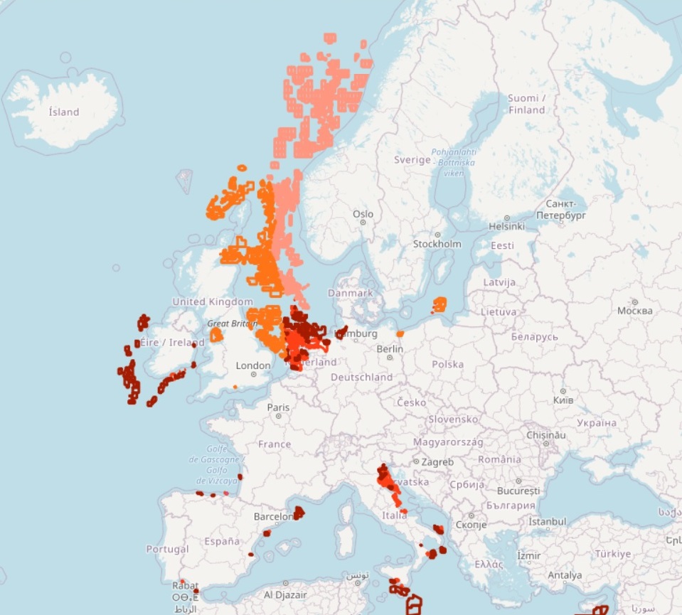
EMODnet Human Activities, Oil and Gas, Active Licences
The dataset on offshore active licences for Oil and Gas exploitation and exploration in the European seas was created in 2014 by Cogea for the European Marine Observation and Data Network (EMODnet). It is the result of the aggregation and harmonization of datasets provided by several EU and non-EU sources. It is available for viewing and download on EMODnet web portal (Human Activities, https://emodnet.ec.europa.eu/en/human-activities). The dataset contains polygons representing the currently active licences in the following countries: Croatia, Cyprus, Denmark, France, Germany, Ireland, Italy, Malta, Netherlands, Norway, Poland, Spain and United Kingdom. Where available each polygon has the following attributes: country, code, name, type (exploitation, exploration, exploitation and exploration, other), licensing round (it includes also pending applications in Spain), area (square km), area info (it indicates if the area value is original from the source or has been calculated), valid from, valid to, operator or administrator, notes. At present, there are no active licenced areas in Portuguese waters, and no information is available regarding other countries.
Simple
- Date (Publication)
- 2014-06-30
- Date (Revision)
- 2026-02-16
- Date (Creation)
- 2014-06-24
- Citation identifier
- EMODnet_HA_OG_ActiveLicences_20260216
- Point of contact
-
Organisation name Individual name Electronic mail address Role Cogea Srl
Author Cyprus - Ministry of Energy, Commerce and Industry - Hydrocarbons Service
Resource provider Spain - Ministerio para la Transición Ecológica y el Reto Demográfico - Archivo Técnico de Hidrocarburos
Resource provider France - Direction Generale de l'energie et du Climat (DGEC) - Bureau de Recherches Geologiques et Minieres (BRGM) - Minergies
Resource provider Ireland - Department of the Environment, Climate and Communications - Integrated Petroleum Affairs System (IPAS)
UK - The North Sea Transition Authority
Poland - Polish Geological Institute - National Research Institute
Resource provider Norway - Norwegian Petroleum Directorate
Resource provider Netherlands - TNO – Geological Survey of the Netherlands
Resource provider Denmark - Danish Energy Agency
Resource provider Italy - Ministero dell'ambiente e della sicurezza energetica - Direzione generale fonti energetiche e titoli abilitativi
Resource provider Portugal - Direção-Geral de Energia e Geologia
Resource provider Germany - Landesamt fur Bergbau, Energie und Geologie
Resource provider Malta - Ministry for Finance - Continental Shelf Department
Resource provider Croatia - Croatian Hydrocarbon Agency
Resource provider
-
GEMET - INSPIRE themes, version 1.0
-
-
Energy resources
-
Area management/restriction/regulation zones and reporting units
-
-
GEMET - Themes, version 2.4
-
-
energy
-
-
GEMET - Concepts, version 3.1
-
-
hydrocarbon
-
oil exploration
-
oil extraction
-
offshore drilling
-
oil production (chain)
-
non-renewable energy resource
-
natural gas extraction
-
natural gas exploration
-
- Spatial representation type
- Vector
- Denominator
- 100000
- Language
- English
- Topic category
-
- Planning cadastre
- Utilities communication
))
- Access constraints
- Other restrictions
- Other constraints
- No limitations on public access
- gmd:useconstraints
- otherRestrictions
- Other constraints
-
Creative Commons CC-BY 4.0 https://creativecommons.org/licenses/by/4.0/
- gmd:useconstraints
- otherRestrictions
- Other constraints
-
This data was downloaded from the EMODnet Portal ( https://emodnet.ec.europa.eu/en/). The data originator is Cogea Srl.
- Reference system identifier
- EPSG:4326
- Reference system identifier
- ISO 19108 calendar
- Transfer size
- 0
- OnLine resource
-
Protocol Linkage Name WWW:LINK
https://emodnet.ec.europa.eu/en/human-activities EMODnet Human Activities
OGC:WMS
https://ows.emodnet-humanactivities.eu/wms? activelicenses
OGC:WFS
https://ows.emodnet-humanactivities.eu/wfs? emodnet:activelicenses
WWW:DOWNLOAD
https://ows.emodnet-humanactivities.eu/geonetwork/srv/api/records/d9da64ae-4bff-4cae-9ee8-58d9acc1d0fe/attachments/EMODnet_HA_OG_ActiveLicences_20260216.zip EMODnet_HA_OG_ActiveLicences_20260216.zip
- Distribution format
-
Name Version Esri geodatabase gco:nilReason="unknown"> Esri shapefile gco:nilReason="unknown">
- Hierarchy level
- Dataset
Conformance result
- Date (Publication)
- 2008-12-04
- Explanation
-
See the referenced specification
- Pass
- Yes
Conformance result
- Date (Publication)
- 2010-12-08
- Explanation
-
See the referenced specification
Conformance result
- Date (Publication)
- 2009-12-15
- Explanation
-
See the referenced specification
- Pass
- Yes
- Statement
-
Data were retrived from different national sources. Validation and quality assurance remain up to primary data sources, while harmonization is carried out by Cogea. The harmonisation process consisted of identifying a set of attributes common to all the different datasets, thus creating a single data model. To do so, it was necessary to define a homogenous set of variables for each attribute. Therefore, raw data attributes may use a different terminology, although the information contained remains basically the same. For further information on validation and quality assurance, it is suggested that primary data sources are contacted. Generally speaking data are to be considered very reliable, because they come from national sources officially in charge for their collection. In Spain, Gaviota is a storage licence (almacenamiento) that was harmonized as'other' type. When areas had to be calculated we used as much as possible the original projected coordinate system of the raw data or the UTM-WGS84 zone that the national data falls in.
Metadata
- File identifier
- d9da64ae-4bff-4cae-9ee8-58d9acc1d0fe XML
- Metadata language
- English
- Character set
- UTF8
- Hierarchy level
- Dataset
- Date stamp
- 2026-02-16T16:45:43.841365Z
- Metadata standard name
-
ISO19115
- Metadata standard version
-
2003/Cor.1:2006
- Metadata author
-
Organisation name Individual name Electronic mail address Role Cogea Srl
Point of contact
Overviews
Spatial extent
Provided by
