EMODnet Human Activities, Other Forms of Area Management, MSFD Reporting Units
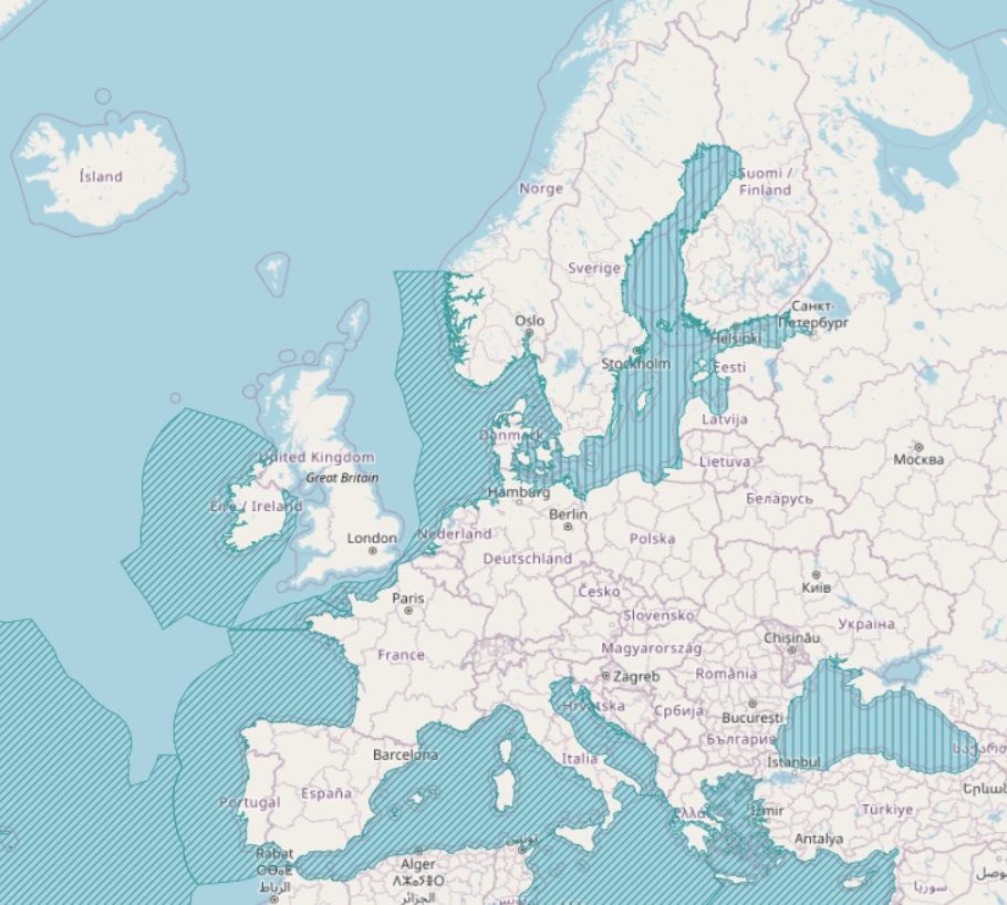
The present layer compiles the marine regions and subregions listed in Article 4 of the Marine Strategy Framework Directive (MSFD), together with other surrounding seas of Europe. The MSFD marine regions and subregions map was developed to support DG Environment and EU Member States in their implementation of the MSFD. It represents the current state of understanding of the marine regions and subregions and is subject to amendment in light of any new information which may be produced
Simple
- Date (Revision)
- 2026-01-09
- Date (Creation)
- 2019-04-15
- Citation identifier
- EMODnet_HA_OtherFormsOfAreaManagement_MSFDReportingUnits_20260109
- Point of contact
-
Organisation name Individual name Electronic mail address Role European Environment Agency
Author Centro Tecnológico del Mar - Fundación CETMAR
Processor
-
INSPIRE feature concept dictionary (Version: Linked Data 1.0)
-
-
Management Restriction Or Regulation Zone
-
-
GEMET - INSPIRE themes, version 1.0
-
-
Area management/restriction/regulation zones and reporting units
-
Maritime boundaries
-
-
GEOSS - Societal Benefit Areas, version 1.0
-
-
Resource management
-
- Access constraints
- Other restrictions
- Other constraints
- No limitations on public access
- gmd:useconstraints
- otherRestrictions
- Other constraints
-
Creative Commons CC-BY 4.0 https://creativecommons.org/licenses/by/4.0/
- gmd:useconstraints
- otherRestrictions
- Other constraints
-
This data was downloaded from the EMODnet Portal ( https://emodnet.ec.europa.eu/en/). The data originator is CETMAR.
- Spatial representation type
- Vector
- Language
- English
- Topic category
-
- Boundaries
))
- Reference system identifier
- EPSG4326
- Reference system identifier
- ISO 19108 calendar
- OnLine resource
-
Protocol Linkage Name WWW:LINK
https://emodnet.ec.europa.eu/en/human-activities EMODnet Human Activities
WWW:DOWNLOAD
https://ows.emodnet-humanactivities.eu/geonetwork/srv/api/records/cb26f323-b50a-4c2a-9f49-6d4bac98e49e/attachments/EMODnet_HA_OtherFormsOfAreaManagement_MSFDReportingUnits_20260109.zip EMODnet_HA_OtherFormsOfAreaManagement_MSFDReportingUnits_20260109.zip
OGC:WMS-1.3.0-http-get-map
https://ows.emodnet-humanactivities.eu/wms? reportingunits
OGC:WFS
https://ows.emodnet-humanactivities.eu/wfs? emodnet:reportingunits
- Distribution format
-
Name Version Esri geodatabase Esri shapefile
- Hierarchy level
- Series
Conformance result
- Date (Publication)
- 2008-12-04
- Explanation
-
See the referenced specification
- Statement
-
The polygons of Marine Reporting Units (regions and subregions) was obtained from the European Environmental Agency. The shapefile has been modified to include the area in km2 which was calculated using the projection ETRS 1989 LAEA. For further information on validation and quality assurance, it is suggested that primary data sources are contacted
Metadata
- File identifier
- cb26f323-b50a-4c2a-9f49-6d4bac98e49e XML
- Metadata language
- English
- Character set
- UTF8
- Hierarchy level
- Dataset
- Date stamp
- 2026-01-26T16:56:06.002798Z
- Metadata standard name
-
ISO19115
- Metadata standard version
-
2003/Cor.1:2006
- Metadata author
-
Organisation name Individual name Electronic mail address Role Centro Tecnológico del Mar - Fundación CETMAR
Point of contact
Overviews
Spatial extent
Provided by
