EMODnet Human Activities, Environment, Natura 2000
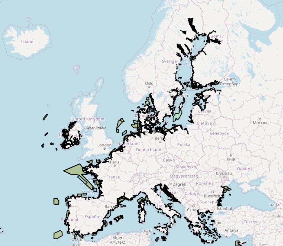
The dataset on Natura 2000 sites was created in 2014 by Cogea for the European Marine Observation and Data Network. It is entirely based on spatial data from the European Environmental Agency (EEA), plus selected EEA tabular data added as feature attributes, as well as the Cogea's calculation of marine and coastal location of features. It is available for viewing and download on the EMODnet web portal (Human Activities, https://emodnet.ec.europa.eu/en/human-activities). Natura 2000 is an ecological network composed of sites designated under the Birds Directive (Special Protection Areas, SPAs) and the Habitats Directive (Sites of Community Importance, SCIs, and Special Areas of Conservation, SACs). The dataset covers the whole EU. Following the United Kingdom’s withdrawal from the EU on 31 January 2020, it ceased to be part of the EEA’s institutional networks and governance. In the webmap the EEA dataset has been filtered to show only (i) marine sites, i.e. sites with a marine area percentage higher than 0 (as calculated by the EEA) and (ii) sites that, even if not identified as marine by the EEA, intersect the EEA coastline or that are within a distance of 1 km from the coastline (using a 1 km inner buffer from the EEA coastline). In both cases the COAST_MAR field value=1. The EEA coastline dataset is available at https://www.eea.europa.eu/data-and-maps/data/eea-coastline-for-analysis-2. Where available, each polygon has the following attributes: site code, site name, country code, country name, site type (A, B, C), site description (Special Conservation Interest - SCI, Special Protection Areas - SPA, Both SPA and SCI), link to directive, area (ha), marine area percentage, release date, date classified as SPA, date confirmed as SCI, date designated as SAC, marine/coastal location of feature (1). Compared with the previous version, this one includes the updated datasets 'eea_v_3035_100_k_natura2000_p_2024_v01_r00' and 'eea_t_natura2000_p_2024_v01_r00', published by the EEA in December 2025. For further information (e.g. biogeographic region, directive, habitats, sites, impact, management, species and metadata) please visit the EEA's website hosting the Natura 2000 tabular data.
Simple
- Date (Publication)
- 2015-10-05
- Date (Revision)
- 2026-02-06
- Date (Creation)
- 2015-08-31
- Citation identifier
- EMODnet_HA_Environment_Natura2000_end2024_20260206
- Point of contact
-
Organisation name Individual name Electronic mail address Role Cogea Srl
Author European Topic Centre on Biological Diversity (ETC/BD)
Resource provider Directorate-General for Environment (DG ENV)
Owner European Environment Agency
Resource provider
-
GEMET - INSPIRE themes, version 1.0
-
-
Area management/restriction/regulation zones and reporting units
-
Land cover
-
Protected sites
-
Habitats and biotopes
-
-
GEMET - Concepts, version 3.1
-
-
protected area
-
natural area
-
natural areas protection
-
- Spatial representation type
- Vector
- Denominator
- 100000
- Language
- English
- Topic category
-
- Environment
))
- Access constraints
- Other restrictions
- Other constraints
- No limitations on public access
- gmd:useconstraints
- otherRestrictions
- Other constraints
-
Creative Commons CC-BY 4.0 https://creativecommons.org/licenses/by/4.0/
- gmd:useconstraints
- otherRestrictions
- Other constraints
-
This data was downloaded from the EMODnet Portal ( https://emodnet.ec.europa.eu/en/). The data originator is Cogea Srl.
- Reference system identifier
- EPSG:4326
- Reference system identifier
- ISO 19108 calendar
- Transfer size
- 0
- OnLine resource
-
Protocol Linkage Name WWW:LINK
https://emodnet.ec.europa.eu/en/human-activities EMODnet Human Activities
WWW:DOWNLOAD
https://ows.emodnet-humanactivities.eu/geonetwork/srv/api/records/ac911c34-1692-4642-a031-87bcb5822158/attachments/EMODnet_HA_Environment_Natura2000_end2024_20260206.zip EMODnet_HA_Environment_Natura2000_end2024_20260206.zip
OGC:WMS
https://ows.emodnet-humanactivities.eu/wms? natura2000areas
OGC:WFS
https://ows.emodnet-humanactivities.eu/wfs? emodnet:natura2000areas
- Distribution format
-
Name Version Esri geodatabase gco:nilReason="unknown"> Esri shapefile gco:nilReason="unknown">
- Hierarchy level
- Dataset
Conformance result
- Date (Publication)
- 2008-12-04
- Explanation
-
See the referenced specification
Conformance result
- Date (Publication)
- 2009-12-15
- Explanation
-
See the referenced specification
Conformance result
- Date (Publication)
- 2010-12-08
- Explanation
-
See the referenced specification
- Statement
-
Validation and quality assurance remain up to the primary data sources, i.e. the European Environmental Agency (EEA). Member States update Natura 2000 spatial data continuously. The EEA integrates and validates the data, producing one release almost once a year. Marine and coastal areas are (i) the ones with a marine area percentage higher than 0 (as reported by the EEA) and (ii) the ones that, even if not identified as marine by the EEA, intersect the coastline or that are within a distance of 1 km from the coastline (using a 1 km inner buffer), as by Cogea's calculation. In both cases the COAST_MAR field value=1. The coastline datasets are available at https://www.eea.europa.eu/data-and-maps/data/eea-coastline-for-analysis-2 for continental areas, and at https://ec.europa.eu/eurostat/web/gisco/geodata/reference-data/administrative-units-statistical-units/countries#countries20 for areas in the overseas entities.
Metadata
- File identifier
- ac911c34-1692-4642-a031-87bcb5822158 XML
- Metadata language
- English
- Character set
- UTF8
- Hierarchy level
- Dataset
- Date stamp
- 2026-02-13T16:51:20.480211Z
- Metadata standard name
-
ISO19115
- Metadata standard version
-
2003/Cor.1:2006
- Metadata author
-
Organisation name Individual name Electronic mail address Role Cogea Srl
Point of contact
Overviews
Spatial extent
Provided by
