EMODnet Human Activities, Other Forms of Area Management, Advisory Councils
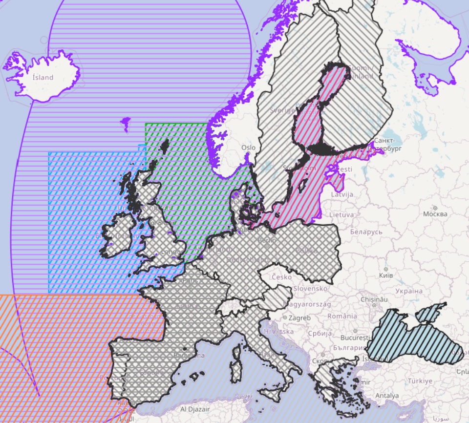
The dataset on the European Union's fisheries Advisory Councils was created in 2014 by CETMAR for the European Marine Observation and Data Network (EMODnet). It is the result of the aggregation and harmonization of datasets provided by several sources. It is updated as soon as any changes are made in any of the Advisory Councils and is available for viewing and download on EMODnet web portal (Human Activities, https://emodnet.ec.europa.eu/en/human-activities). The dataset contains polygons representing the geographical scope, jurisdiction and information for each of the Advisory Councils of the European sea basins. Each polygon has the following attributes (where available): Name, Members, Scope, Sea basin, Legal foundation date, Legal foundation document and a URL-link to the Advisory Council's website.
Simple
- Date (Publication)
- 2014-05-18
- Date (Revision)
- 2025-11-14
- Date (Creation)
- 2014-05-18
- Citation identifier
- EMODnet_HA_AdvisoryCouncils_20251114
- Point of contact
-
Organisation name Individual name Electronic mail address Role Centro Tecnológico del Mar - Fundación CETMAR
Author Aquaculture Advisory Council
Resource provider Baltic Sea Advisory Council
Resource provider Black Sea Advisory Council
Resource provider European Commission
-
Resource provider Long Distance Fleet Advisory Council
Resource provider Market Advisory Council
Resource provider Mediterranean Advisory Council
Resource provider North Sea Advisory Council
via website: https://www.nsrac.org/contact/ ( [email protected] and [email protected] )
Resource provider North Western Waters Advisory Council
Resource provider Outermost Regions Advisory Council
Resource provider Pelagic Advisory Council (EU)
Resource provider South Western Waters Advisory Council
via website form: https://cc-sud.eu/en/contact-us/
Resource provider
-
GEMET - INSPIRE themes, version 1.0
-
-
Area management/restriction/regulation zones and reporting units
-
-
GEMET - Concepts, version 4.2.3
-
-
fishing
-
fisheries management
-
- Denominator
- 100000
- Language
- English
))
- Begin date
- 2014-05-18
- Access constraints
- Other restrictions
- Other constraints
- No limitations on public access
- gmd:useconstraints
- otherRestrictions
- Other constraints
-
Creative Commons CC-BY 4.0 https://creativecommons.org/licenses/by/4.0/
- gmd:useconstraints
- otherRestrictions
- Other constraints
-
This data was downloaded from the EMODnet Portal ( https://emodnet.ec.europa.eu/en/). The data originator is CETMAR.
- OnLine resource
- Distribution format
-
Name Version Esri geodatabase gco:nilReason="unknown"> Esri shapefile gco:nilReason="unknown">
- Hierarchy level
- Dataset
Conformance result
- Date (Publication)
- 2008-12-04
- Explanation
-
See the referenced specification
Conformance result
- Date (Publication)
- 2009-12-15
- Explanation
-
See the referenced specification
Conformance result
- Date (Publication)
- 2010-12-08
- Explanation
-
See the referenced specification
- Statement
-
Data were retrieved from different sources. Validation and quality assurance remain up to primary data sources, while harmonization is carried out by CETMAR. For further information on validation and quality assurance, it is suggested that primary data sources are contacted.
Metadata
- File identifier
- 7e539449-48b8-4e5f-87f3-e5e2ff4cfe1b XML
- Metadata language
- English
- Character set
- MD_CharacterSetCode_utf8
- Hierarchy level
- Dataset
- Date stamp
- 2026-03-18T09:42:02.097673Z
- Metadata standard name
-
ISO19115
- Metadata standard version
-
2003/Cor.1:2006
- Metadata author
-
Organisation name Individual name Electronic mail address Role Centro Tecnológico del Mar - Fundación CETMAR
Point of contact
Overviews
Spatial extent
Provided by
