EMODnet Human Activities, Maritime Spatial Planning (MSP)
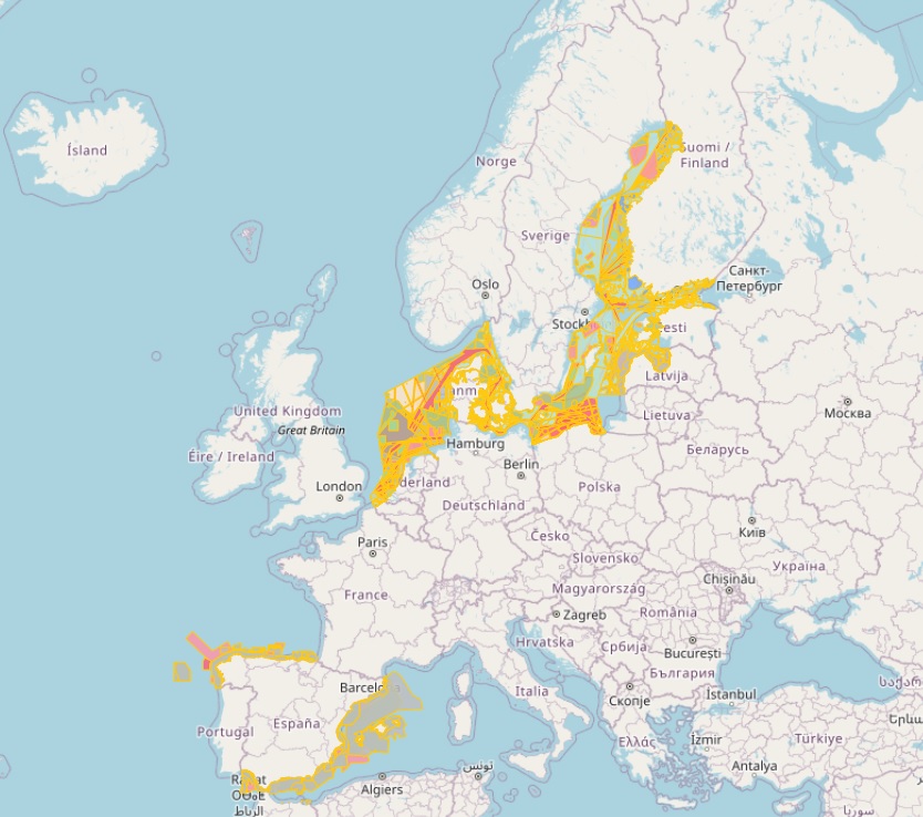
The dataset on Maritime Spatial Planning (MSP) in the EU was created in 2021 by CETMAR for the European Marine Observation and Data Network (EMODnet). It is the result of the aggregation and harmonization of datasets provided by several sources. It is released as soon a new plan is adopted or updated by an EU member state and it is available for viewing and download on EMODnet web portal (Human Activities, https://emodnet.ec.europa.eu/en/human-activities). The dataset contains polygons, points and lines representing Maritime Spatial Planning (MSP) in the following countries: Belgium, Denmark, Estonia, Finland, Germany, Italy, Latvia, Lithuania, Netherlands, Poland, Spain and Sweden. The MSP dataset is made up of 3 types of spatial features: MSP Spatial Plan, MSP Zoning Element and MSP Supplementary Regulation. Also there is a non spatial feature called MSP Official Documentation. The distance to coast (EEA coastline shapefile) has been calculated using the UTM WGS84 Zone projected coordinate system where data fall in. The MSP datasets shown on the EMODnet portal do not represent agreed maritime boundaries and are therefore without prejudice to the sovereign rights of the relevant States. Any datasets shown cannot be used as a claim by a State for its continental shelf or exclusive economic zone extents and sovereign rights.
Simple
- Date (Publication)
- 2021-01-22
- Date (Revision)
- 2025-12-03
- Date (Creation)
- 2021-01-22
- Citation identifier
- EMODnet_HA_MSP_20251203
- Point of contact
-
Organisation name Individual name Electronic mail address Role Centro Tecnológico del Mar - Fundación CETMAR
Author Federal Public Service (FPS) Health, Food Chain Safety and Environment
Resource provider Danish Maritime Authority (Secretariat for maritime spatial planning)
[email protected] , [email protected] , [email protected] and [email protected]
Resource provider Ministry of Finance (Planning Department) (Rahandusministeerium)
Resource provider Ministry of The Environment and Regionals councils (Uusimaa, Kymenlaakso, Southwest Finland, Satakunta, Ostrobothnia, Central Ostrobothnia, North Ostrobothnia and Lapland)
Resource provider Åland Provincial Government
Resource provider Bundesamt für Seeschifffahrt und Hydrographie (BSH)
Resource provider Ministry of Infrastructure and Transport
Resource provider Ministry of Environmental Protection and Regional Development of The Republic of Latvia
Resource provider Ministry of Infrastructure and the Environment (Noordzeeloket)
Resource provider Ministry of Maritime Economy and Inland Navigation, Maritime offices of Gdynia, Slupsk and Szczecin
Resource provider Government of Spain - Ministry for Ecological Transition and the Demographic Challenge
Resource provider Swedish Agency for Marine and Water Management
Resource provider Ministry of Environment of the Republic of Lithuania
Resource provider
-
GEMET - INSPIRE themes, version 1.0
-
-
Land use
-
-
GEMET - Concepts, version 4.1.4
-
-
coastal zone planning
-
land use planning
-
national planning
-
policy planning
-
- Denominator
- 100000
- Language
- English
))
- Begin date
- 2021-01-22
- Access constraints
- Other restrictions
- Other constraints
- No limitations on public access
- gmd:useconstraints
- otherRestrictions
- Other constraints
-
Creative Commons CC-BY 4.0 https://creativecommons.org/licenses/by/4.0/
- gmd:useconstraints
- otherRestrictions
- Other constraints
-
This data was downloaded from the EMODnet Portal ( https://emodnet.ec.europa.eu/en/). The data originator is CETMAR.
- OnLine resource
-
Protocol Linkage Name WWW:LINK
https://emodnet.ec.europa.eu/en/human-activities EMODnet Human Activities
OGC:WMS
https://ows.emodnet-humanactivities.eu/wms? mspspatialplan
OGC:WMS-1.3.0-http-get-map
https://ows.emodnet-humanactivities.eu/wms? mspzoningpoly
OGC:WMS-1.3.0-http-get-map
https://ows.emodnet-humanactivities.eu/wms? mspzoningline
OGC:WMS-1.3.0-http-get-map
https://ows.emodnet-humanactivities.eu/wms? mspzoninglocs
OGC:WFS
https://ows.emodnet-humanactivities.eu/wfs? emodnet:mspspatialplan
OGC:WFS
https://ows.emodnet-humanactivities.eu/wfs? emodnet:mspzoningpoly
OGC:WFS
https://ows.emodnet-humanactivities.eu/wfs? emodnet:mspzoningline
OGC:WFS
https://ows.emodnet-humanactivities.eu/wfs? emodnet:mspzoninglocs
WWW:DOWNLOAD-1.0-http--download
https://ows.emodnet-humanactivities.eu/geonetwork/srv/api/records/5d89d371-a52a-476b-92de-a423f6d2c15d/attachments/EMODnet_HA_MSP_20251203.zip EMODnet_HA_MSP_20251203.zip
- Distribution format
-
Name Version Esri geodatabase Esri shapefile
- Hierarchy level
- Dataset
Conformance result
- Date (Publication)
- 2008-12-04
- Explanation
-
See the referenced specification
Conformance result
- Date (Publication)
- 2009-12-15
- Explanation
-
See the referenced specification
Conformance result
- Date (Publication)
- 2010-12-08
- Explanation
-
See the referenced specification
- Statement
-
Data were retrieved from different countries, i.e. Belgium, Denmark, Estonia, Finland, Germany, Italy, Latvia, Lithuania, Netherlands, Poland, Spain and Sweden. Validation and quality assurance remain up to primary data sources, while harmonization is carried out by CETMAR. This harmonization process consists of adapting all the MSP plans developed by the EU member states in a common data model, which was created from the INSPIRE conceptual model of Planned Land Use as described in https://cinea.ec.europa.eu/publications/proposal-making-harmonized-msp-plan-data-available-across-europe-0_en. For further information on validation and quality assurance, it is suggested that primary data sources are contacted. Generally speaking data are to be considered very reliable, because they come from national sources officially in charge for their collection.
Metadata
- File identifier
- 5d89d371-a52a-476b-92de-a423f6d2c15d XML
- Metadata language
- English
- Character set
- MD_CharacterSetCode_utf8
- Hierarchy level
- Dataset
- Date stamp
- 2026-03-03T11:50:28.205544Z
- Metadata standard name
-
ISO19115
- Metadata standard version
-
2003/Cor.1:2006
- Metadata author
-
Organisation name Individual name Electronic mail address Role Centro Tecnológico del Mar - Fundación CETMAR
Point of contact
Overviews
Spatial extent
Provided by
