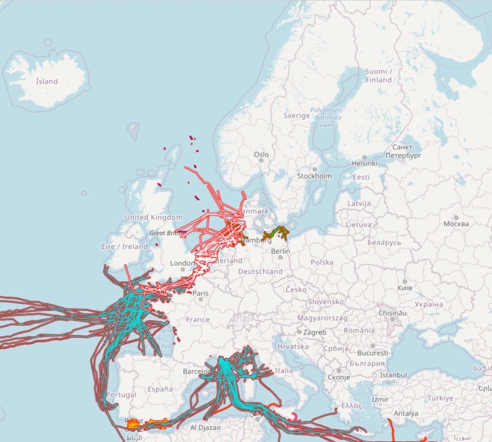
EMODnet Human Activities, Cables, Telecommunication, Actual Routes
The dataset on subsea telecommunication cables in the European waters was created in 2014 by Cogea for the European Marine Observation and Data Network (EMODnet). It is the result of the aggregation of datasets provided by several EU and non-EU sources. It is updated every year, and is available for viewing and download on the EMODnet web portal (Human Activities, https://emodnet.ec.europa.eu/en/human-activities). The dataset contain lines representing actual cable routes locations. Compared with the previous version, this version includes an update of the German cables.
Simple
- Date (Publication)
- 2015-01-15
- Date (Revision)
- 2023-06-28
- Date (Creation)
- 2014-12-22
- Citation identifier
- EMODnet_HA_Cables_Telecommunication_20230628
- Point of contact
-
Organisation name Individual name Electronic mail address Role Cogea Srl
Author Germany - Federal Maritime and Hydrographic Agency
Resource provider Spain - Centro Informático Científico de Andalucía (CICA)
Resource provider France - SIGCables - Orange ©
Resource provider France - Service hydrographique et océanographique de la Marine (Shom)
Resource provider Malta - International Ocean Institute - Malta Operational Centre (University Of Malta) / Physical Oceanography Unit
Netherlands - Rijkswaterstaat
United Kingdom - Oil and Gas Authority (OGA)
Resource provider
-
GEMET - INSPIRE themes, version 1.0
-
-
utilitiesCommunication
-
Utility and governmental services
-
- Spatial representation type
- Vector
- Denominator
- 100000
- Language
- English
- Topic category
-
- Planning cadastre
- Utilities communication
))
- Access constraints
- Other restrictions
- Other constraints
- No limitations on public access
- gmd:useconstraints
- otherRestrictions
- Other constraints
-
Creative Commons CC-BY 4.0 https://creativecommons.org/licenses/by/4.0/
- gmd:useconstraints
- otherRestrictions
- Other constraints
-
This data was downloaded from the EMODnet Portal ( https://emodnet.ec.europa.eu/en/). The data originator is Cogea Srl.
- Reference system identifier
- EPSG:4326
- Reference system identifier
- ISO 19108 calendar
- Transfer size
- 0
- OnLine resource
- Distribution format
-
Name Version Esri geodatabase gco:nilReason="unknown"> Esri shapefile gco:nilReason="unknown">
- Hierarchy level
- Dataset
Conformance result
- Date (Publication)
- 2008-12-04
- Explanation
-
See the referenced specification
- Pass
- Yes
Conformance result
- Date (Publication)
- 2010-12-08
- Explanation
-
See the referenced specification
Conformance result
- Date (Publication)
- 2009-12-15
- Explanation
-
See the referenced specification
- Pass
- Yes
- Statement
-
Data were retrived from 7 different sources. Validation and quality assurance remain up to the primary sources. Cogea simply retrieved the information available online or submitted by data sources, except for Maltese cables that have been edited in a shapefile using tabular data of coordinates submitted via EMODnet Data Ingestion portal by the International Ocean Institute-Malta Operational Centre (University Of Malta)/Physical Oceanography Unit.
Metadata
- File identifier
- 39ebe289-410b-4a5d-88a4-51bfcde538de XML
- Metadata language
- English
- Character set
- UTF8
- Hierarchy level
- Dataset
- Date stamp
- 2025-09-02T08:37:52.974965Z
- Metadata standard name
-
ISO19115
- Metadata standard version
-
2003/Cor.1:2006
- Metadata author
-
Organisation name Individual name Electronic mail address Role Cogea Srl
Point of contact
Overviews
Spatial extent
Provided by
