EMODnet Human Activities, Environment, Nationally Designated Areas
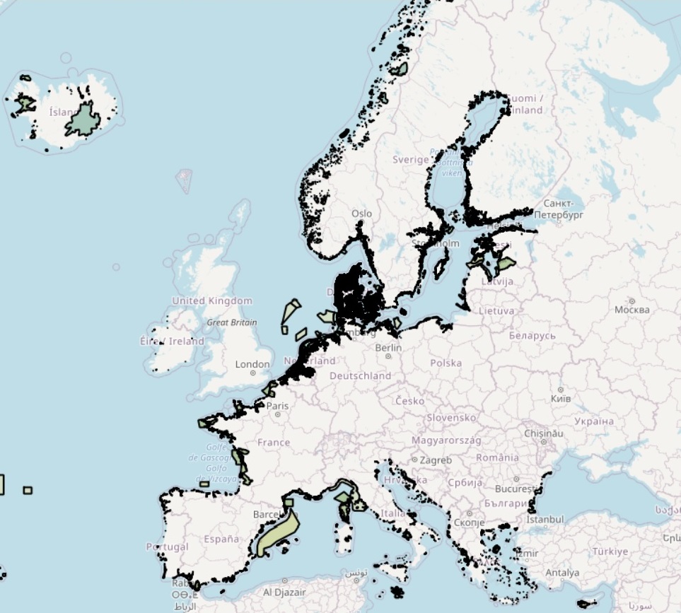
The dataset on Nationally Designated Areas was created in 2014 by Cogea for the European Marine Observation and Data Network (EMODnet). It includes polygons and points and it is based on the 'NatDA_2025_v01_public' both geographical and tabular datasets from the European Environmental Agency (EEA) and it is available for viewing and download on EMODnet web portal (Human Activities, https://emodnet.ec.europa.eu/en/human-activities). The European inventory of Nationally designated areas holds information about designated areas and their designation types, which directly or indirectly create protected areas. The Nationally designated areas is the official source of protected area information from the 38 European member countries to the World Database of Protected Areas (WDPA). The inventory began in 1995 under the CORINE programme of the European Commission. The NatDA is now an agreed annual Eionet core data flow maintained by the European Environment Agency (EEA) with support from the European Topic Centre on DataIntegration and Digitalisation (ETC DI). The dataset is used by the EEA and e.g. the UNEP-WCMC for their main European and global assessments, products and services. The data can be queried online in the European Nature Information System (EUNIS). Geographical coverage: Albania, Austria, Belgium, Bosnia and Herzegovina, Bulgaria, Croatia, Cyprus, Czech Republic, Denmark, Estonia, Finland, France, Germany, Greece, Hungary, Iceland, Ireland, Italy, Kosovo (under UNSC Resolution 1244/99), Latvia, Liechtenstein, Lithuania, Luxembourg, Malta, Montenegro, Netherlands, North Macedonia, Norway, Poland, Portugal, Romania, Serbia, Slovakia, Slovenia, Spain, Sweden and Switzerland. The EEA does not have permission to distribute some or all sites reported by Estonia, Ireland and Türkiye. In the webmap the dataset has been filtered in order to show only marine and coastal areas. Where available each polygon/point has the following main attributes: CDDA ID, country code, country name, site name, legal foundation date, national ID, area type/code (Designated Boundary or Site), IUCN category/description (Ia: Strict Nature Reserve; Ib: Wilderness Area; II: National Park; III: Natural Monument or Feature; IV: Habitat/Species Management Area; V: Protected Landscape/ Seascape; VI: Protected area with sustainable use of natural resources; Not applicable; Not assigned; Not reported. For more information please check the 'Guidelines for Applying Protected
Area Management Categories' available at: https://portals.iucn.org/library/sites/library/files/documents/PAG-021.pdf), area (ha), major ecosystem type (Marine, Marine and terrestrial, Terrestrial), marine area percentage, spatial resolution (Scale 100K-250K, Scale Larger 100K, Unknown), remarks, marine/coastal location of features (1) as per Cogea's calulation. For further information please visit the EEA's website. Compared with the previous release, this one includes the public version 23.00 of the Nationally designated areas dataset published by the EEA in August 2025.
Simple
- Date (Publication)
- 2014-10-05
- Date (Revision)
- 2025-10-22
- Date (Creation)
- 2014-08-31
- Citation identifier
- EMODnet_HA_Environment_NatDA_2025_v01_public_20251022
- Point of contact
-
Organisation name Individual name Electronic mail address Role Cogea Srl
Author European Topic Centre on Biological Diversity (ETC/BD)
Resource provider Directorate-General for Environment (DG ENV)
Owner European Environment Agency
Resource provider
-
GEMET - INSPIRE themes, version 1.0
-
-
Area management/restriction/regulation zones and reporting units
-
Land cover
-
Protected sites
-
Habitats and biotopes
-
-
GEMET - Concepts, version 3.1
-
-
protected area
-
natural area
-
natural areas protection
-
- Access constraints
- Other restrictions
- Other constraints
- No limitations on public access
- gmd:useconstraints
- otherRestrictions
- Other constraints
-
Creative Commons CC-BY 4.0 https://creativecommons.org/licenses/by/4.0/
- gmd:useconstraints
- otherRestrictions
- Other constraints
-
This data was downloaded from the EMODnet Portal ( https://emodnet.ec.europa.eu/en/). The data originator is Cogea Srl.
- Spatial representation type
- Vector
- Denominator
- 100000
- Language
- English
- Topic category
-
- Environment
))
- Reference system identifier
- EPSG:4326
- Reference system identifier
- ISO 19108 calendar
- Transfer size
- 0
- OnLine resource
-
Protocol Linkage Name WWW:LINK
https://emodnet.ec.europa.eu/en/human-activities EMODnet Human Activities
OGC:WMS
https://ows.emodnet-humanactivities.eu/wms? cddaareas
OGC:WFS
https://ows.emodnet-humanactivities.eu/wfs? emodnet:cddaareas
WWW:DOWNLOAD
https://ows.emodnet-humanactivities.eu/geonetwork/srv/api/records/3362d8b1-a12e-4d1d-a0d8-1834e9db00f3/attachments/EMODnet_HA_Environment_NatDA_2025_v01_public_20251022.zip EMODnet_HA_Environment_NatDA_2025_v01_public_20251022.zip
OGC:WMS
https://ows.emodnet-humanactivities.eu/wms? cddalocations
OGC:WFS
https://ows.emodnet-humanactivities.eu/wfs? emodnet:cddalocations
- Distribution format
-
Name Version Esri geodatabase
- Hierarchy level
- Dataset
Conformance result
- Date (Publication)
- 2008-12-04
- Explanation
-
See the referenced specification
Conformance result
- Date (Publication)
- 2009-12-15
- Explanation
-
See the referenced specification
Conformance result
- Date (Publication)
- 2010-12-08
- Explanation
-
See the referenced specification
- Statement
-
Validation and quality assurance remain up to the primary data sources, i.e. the European Environmental Agency (EEA). Data deliveries from the Eionet, the partnership network of the EEA and its 38 member and cooperating countries. In EU Member States the implementation of INSPIRE Directive may mean that the spatial information is provided via the national or sub-national INSPIRE data providers. Marine and coastal areas are (i) the ones with a marine area percentage higher than 0 (as reported by the EEA) and/or a 'marine' ecotype (as calculated or reported by the EEA), and (ii) the ones that, even if not identified as marine by the EEA, intersect the coastline or that are within a distance of 1 km from the coastline (using a 1 km inner buffer), as by Cogea's calculation. In both cases the COAST_MAR field value=1. The coastline datasets are available at https://www.eea.europa.eu/data-and-maps/data/eea-coastline-for-analysis-2 for continental areas, and at https://ec.europa.eu/eurostat/web/gisco/geodata/reference-data/administrative-units-statistical-units/countries#countries20 for areas in the overseas entities.
Metadata
- File identifier
- 3362d8b1-a12e-4d1d-a0d8-1834e9db00f3 XML
- Metadata language
- English
- Character set
- UTF8
- Hierarchy level
- Dataset
- Date stamp
- 2025-11-06T10:37:26.556889Z
- Metadata standard name
-
ISO19115
- Metadata standard version
-
2003/Cor.1:2006
- Metadata author
-
Organisation name Individual name Electronic mail address Role Cogea Srl
Point of contact
Overviews
Spatial extent
Provided by
