EMODnet Human Activities, Desalination, Plants
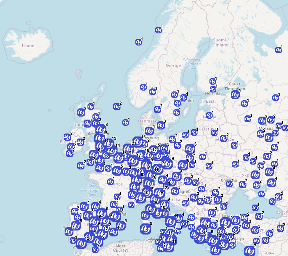
The database on Desalination plants in the EU was created in 2021 by Cogea Srl for the European Marine Observation and Data Network (EMODnet). It is the result of the harmonization of a dataset provided by GWI DesalData. The dataset provides spatial information (point) on the centroid of the municipality where a given plant is located. It is available for viewing and download on EMODnet - Human Activities web portal ( https://emodnet.ec.europa.eu/en/human-activities) and will be updated every year. The dataset covers the following countries: Albania, Austria, Belgium, Belarus, Bosnia and Herzegovina, Bulgaria, Croatia, Cyprus, Czech Republic, Denmark, Finland, France, Georgia, Germany, Gibraltar, Greece, Guernsey, Hungary, Ireland, Italy, Jersey, Latvia, Liechtenstein, Lithuania, Luxembourg, Malta, Moldova, Netherlands, Norway, Poland, Portugal, Romania, Russia, Serbia, Slovakia, Slovenia, Spain, Sweden, Switzerland, Turkey, UK, Ukraine. Where available, each point has the following attributes: site code (ID), Location Name, Country, Position Source, Commune Name, NUTS code (NUTS 3 ID), Latitude, Longitude. A relational table provides further information for each desalination plant where data are available: Location Type, Project, Capacity (m3/d), Size, Units, Unit Size (m3/d), Technology, Feedwater, Plant Type, Award Date, Online Date, Plant Status, Customer Type, Industry Type, Customer, Holding Company, Plant Owner. More plant-specific information is available in the original dataset.
Simple
- Date (Publication)
- 2021-09-15
- Date (Revision)
- 2021-08-30
- Date (Creation)
- 2021-08-30
- Citation identifier
- EMODnet_HA_Desalination_Plants_20210830
- Point of contact
-
Organisation name Individual name Electronic mail address Role Cogea Srl
Author GWI DesalData
Resource provider Eurostat - GISCO
Resource provider ESRI
Resource provider GeoNames
Resource provider
-
GEMET - Concepts, version 4.2.1, 1 Jun 2021
-
-
Desalination plant
-
-
GEMET - Themes, version 4.2.1, 1 Jun 2021
-
-
building
-
-
GEMET - Themes, version 4.2.1, 1 Jun 2021
-
-
food, drinking water
-
-
GEMET - Themes, version 4.2.1, 1 Jun 2021
-
-
industry
-
-
GEMET - Themes, version 4.2.1, 1 Jun 2021
-
-
water
-
- Spatial representation type
- Vector
- Denominator
- 100000
- Language
- English
))
- Access constraints
- Other restrictions
- Other constraints
- No limitations on public access
- gmd:useconstraints
- otherRestrictions
- Other constraints
-
Creative Commons CC-BY 4.0 https://creativecommons.org/licenses/by/4.0/
- gmd:useconstraints
- otherRestrictions
- Other constraints
-
This data was downloaded from the EMODnet Portal ( https://emodnet.ec.europa.eu/en/). The data originator is Cogea Srl.
- Transfer size
- 0
- OnLine resource
-
Protocol Linkage Name WWW:LINK
https://emodnet.ec.europa.eu/en/human-activities EMODnet Human Activities
WWW:DOWNLOAD
https://ows.emodnet-humanactivities.eu/geonetwork/srv/api/records/18d9daa1-eee4-4380-a2d0-fd20e4b47081/attachments/EMODnet_HA_Desalination_Plants_20210830.zip EMODnet_HA_Desalination_Plants_20210830.zip
OGC:WMS
https://ows.emodnet-humanactivities.eu/wms? desalination
OGC:WFS
https://ows.emodnet-humanactivities.eu/wfs? emodnet:desalination
- Distribution format
-
Name Version Esri geodatabase gco:nilReason="unknown"> Esri shapefile gco:nilReason="unknown">
- Hierarchy level
- Dataset
Conformance result
- Date
- 2021-08-30
- Explanation
-
See the referenced specification
- Statement
-
The EMODnet dataset on Desalination plants in the EU is based on an existing dataset provided by GWI DesalData. The geographic coordinates of plant locations provided by the GWI dataset were subjected to quality control. Coordinates were deemed correct when: (i) the original location name matched the name of the municipality polygon that contained the point, polygons being provided by an official provider (i.e., GISCO); (ii) the original location was confirmed to lie within a GISCO polygon. In such cases, we georeferenced the location to the centroid of the GISCO polygon that contained the original point. When a point fell outside the GISCO limits, we either assigned coordinates from a different source (i.e., ESRI) or kept the GWI DESALDATA coordinates (e.g., offshore plants). When the coordinates appeared incorrect, we georeferenced the location to the country capital. If the point was located on an island, we georeferenced the location to the county seat. Sarajevo was assigned coordinates provided by a different source (i.e., GeoNames). Plant-specific information was related to each location point by a one-to-many type of relationship and summarized by a relational table.
Metadata
- File identifier
- 18d9daa1-eee4-4380-a2d0-fd20e4b47081 XML
- Metadata language
- English
- Character set
- MD_CharacterSetCode_utf8
- Hierarchy level
- Dataset
- Date stamp
- 2025-08-29T09:51:23.138276Z
- Metadata standard name
-
ISO19115
- Metadata standard version
-
2003/Cor.1:2006
- Metadata author
-
Organisation name Individual name Electronic mail address Role Cogea Srl
Point of contact
Overviews
Spatial extent
Provided by
